Small nondescript swells all week, ahead of a small fun weekend from the south

Sydney, Hunter and Illawarra Surf Forecast by Ben Matson (issued Monday 22nd August)
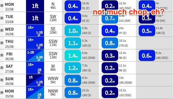
Best Days: No great days this week due to flukey swell sources and tricky winds. Sat/Sun: Small clean waves at south facing beaches. Mon/Tues/Wed: stronger S'ly swell with offshore winds.
Recap: Wave heights have remained pretty small for the last few days, being a mix of NE windswell on Saturday, a small south swell today, and a minor underlying trade swell for the entire period.
This week (Tuesday 23rd - Friday 26th)
The synoptic charts remain ‘interesting’ per se, much as they did on Friday, but unfortunately there’s very little swell on the way.
Right now we have a minor combo of swells in the water and this pattern is expected to continue into Tuesday. A small long period E/NE swell is expected to arrive throughout the day, generated by a deep low E/NE of New Zealand late last week however this system was located well and truly inside the swell shadow of the North Island. As such, the swell energy we see across Southern NSW will be very small and inconsistent.
I’m not expecting much more than a slow 1-2ft at best at exposed beaches, building through Tuesday afternoon and persisting through Wednesday and Thursday, possibly even Friday. Expect lengthy periods of tiny conditions from this direction at times.
Wednesday has a small new S’ly tending S/SE swell on the cards, originating from the remnants of an intense Southern Ocean low that bombed W/SW of Tasmania late last week. It finally moved into our swell window yesterday, displaying two poorly aligned fetches for Southern NSW - a modest trailing SW flow behind the associated cold front, plus a SE tending E/SE fetch off the bottom of the trough. This second fetch ended up being much less favourable in alignment than Friday’s forecast suggested so swell prospects for the second half of the week have been scaled back from this source.
South facing beaches should pick up occasional 2ft+ sets through Wednesday and early Thursday, possibly a few bigger bombs across reliable swell magnets such as the Northern Hunter. Local winds are looking pretty suss on Wednesday though, with an unrelated local trough expected to form off the Sydney/Hunter region that could very well drive gusty S/SE winds across the coastal margin.
This surface trough looks like it’ll be captured by a fast moving upper trough to the north, which will probably whisk it out to the east before it creates any appreciable swell increase. A small local windswell is possible later Wednesday or early Thursday, but this is unlikely to have any quality and would probably be confined to the Sydney/Hunter region at best.
A local troughy pattern is expected to hang across the region through Thursday, maintaining southerly winds, but it’ll probably swing W/SW early morning under the influence of local topographical effects (the Hunter may dip out though, if that surface trough lingers a little longer than expected).
The only other source of new swell this week is a moderate front moving through the Southern Tasman Sea around Thursday. This is likely to kick up a small S’ly swell for Friday - possibly not arriving in the morning but pushing through from lunchtime onwards - and I’m not expecting much more than slow 2ft+ sets at south facing beaches (again, possibly a fraction higher across the Hunter). Conditions look dicey to finish the week with the coastal trough persisting, and eat SW winds likely to swing moderate to fresh S’ly.
So all in all, marginal swells and tricky winds means that surfing shouldn’t be particularly high on your agenda for the rest of this week.
This weekend (Saturday 27th - Sunday 28th)
At this stage, the weekend looks mainly small from the south.
Our small easterly swell source will be all but gone by this time, and a series of modest fronts traversing the Southern Ocean are expected to generate minor levels of southerly energy for both days.
Current expectations are for slow sets in the 2ft+ range at south facing beaches (slightly larger in the Hunter) but the key feature will likely be an improvement in surface conditions as a series of stronger fronts passing to the south push the troughy coastal pattern out into the Tasman Sea. This should result in light variable winds both days.
These fronts wil generate better southerly swells for the start of next week, though the leading edge of the first swell may reach the Far South Coast late Saturday. I’ll have more details on this in Wednesday’s notes.
Next week (Monday 29th onwards)
As mentioned above, a strong succession of Southern Ocean fronts are expected to line up below Tasmania over the weekend. They won’t be particularly well aligned for our coast, but the fetch length will be considerable, and surface winds will be pretty strong - so we should see some long period energy filling in on Monday, providing set waves somewhere between 3ft and 4ft at south facing beaches (another foot, maybe two bigger across the Northern Hunter). Expect smaller surf at beaches not open to the south.
Early indications are for clean conditions under a moderate NW airstream, and at this stage this regime looks like it’ll remain in place for a little while - so southerly swells will remain firmly on the agenda for the rest of next week and the following weekend.
See you Wednesday!
Comments
After a good run of swell through much of the winter, we have really hit a dry, or wet, spot. Nothing much exciting in the charts for the foreseeable future. Desperately looking for a good line up of swell for a long weekend but the more I look the further away it gets.
Perhaps I should stop looking.
New board on the way, so the swell drought may last for months.