Fun days ahead

Southern Tasmanian Surf Forecast by Craig Brokensha (issued Wednesday March 27th)
Best Days: Tomorrow morning, Friday morning, Saturday
Features of the Forecast (tl;dr)
- Small SW swell tomorrow with W/NW tending SW then SE winds, fresh S/SE later
- Inconsistent W/SW swell Fri with N/NW winds ahead of fresh S/SE sea breezes
- Good SW groundswell building Sat, peaking in the PM, easing Sun
- Light N/NW winds, with weaker sea breezes Sat, S Sun
- Smaller Mon with N/NW tending S/SE winds
Recap
Monday afternoon's strong pulse of swell eased back into yesterday, down from mostly 3ft across Clifton, smaller and to 2ft on the sets this morning.

Good though straight sets yesterday AM
This week and weekend (Mar 28 - 31)
The swell from earlier in the week will continue to fade throughout tomorrow but a small, reinforcing mid-period SW swell should offer fun 2ft sets across Clifton.
Into Friday an inconsistent mid-period W/SW swell is due to arrive, generated by a fetch of strong W/NW winds east of the Heard Island region.
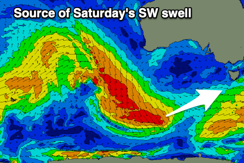
Infrequent 1-2ft sets are due off this source, with some better SW groundswell arriving Saturday.
This will be generated by a healthy fetch of NW gales projecting south-east towards the polar shelf, with a good kick to 2-3ft through the day across Clifton, easing back from 2ft+ on Sunday morning.
Local winds look OK but not perfect tomorrow with a light W/NW offshore, shifting SW, then SE, freshening from the S/SE through the day.
Friday should be nice and clean with a light N/NW offshore ahead of fresh S/SE sea breezes, similar Saturday but with less strength to the sea breeze.
Sunday looks dicey with a trough moving in Saturday evening possibly leaving lingering S'ly winds, back offshore Monday with fading 1-1.5ft surf.
As touched on Monday, strengthening polar frontal activity should bring building levels of SW swell through the middle of next week, with the initial systems being relatively weak. There's stronger activity due into next weekend, but at this stage it looks like sets will reach 3ft on Wednesday though a deepening trough forming into a low may bring strong S/SE-S winds and some localised windswell.
We'll have to have a closer look at this Friday.