Good run of swell and conditions

Southern Tasmanian Surf Forecast by Craig Brokensha (issued Friday March 22nd)
Best Days: This afternoon, tomorrow, Sunday, Monday, Tuesday ahead of the change, early Wednesday
Features of the Forecast (tl;dr)
- Building W/SW swell Fri PM, peaking tomorrow, holding Sun AM
- NW-N/NW tending variable winds tomorrow
- Stronger mid-period SW swell building Sun PM with fresh NW tending strong W/NW winds
- Large SW groundswell Mon with strong NW tending W/NW winds
- Easing swell Tue with strong W/NW-NW winds, tending S/SW later
- Smaller Wed with W/NW tending fresh W/SW-SW winds
Recap
Fun waves yesterday morning with clean conditions and 2ft sets, 1-2ft this morning. Conditions are still clean this afternoon with a bit more size to 2ft on the beaches.
This weekend and next week (Mar 23 - 29)
Today's building energy is thanks to a healthy polar frontal progression moving through our swell window the last two days. We should see tomorrow coming in at 2ft+, similar Sunday morning along with clean conditions.
A NW-N/NW offshore is due tomorrow morning, variable into the afternoon and then fresher NW tending strong W/NW on Sunday.
This strengthening wind will be linked to the northern flank of a strong polar low moving across the state, with building mid-period SW energy due into the afternoon Sunday, reaching 3ft or so, if not a little bigger on dark.
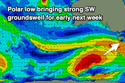
Of greater importance is the swell due from the low itself, with a great fetch of gale to severe-gale W/SW winds firing up south of Western Australia today, projecting east over the coming days. It will then be followed by one final mid-latitude front, passing across us Monday, but no noticeable swell is due from this system.
The groundswell from the polar low will be strongest, arriving from a SW direction and peaking Monday to 4-5ft, then easing slowly Tuesday from 3-4ft.
Winds on Monday look gusty from the NW, shifting strong W/NW through the day, holding W/NW-NW through Tuesday ahead of a late S/SW change. Winds look to hold from the W/SW-SW on Wednesday but morning W/NW winds are likely early with smaller, fading surf.
Longer term there are a couple of swell possibilities, with south-east tracking lows due to intensify on the polar shelf, in our south-western swell window, possibly producing good swells for next weekend. More on this Monday. Have a great weekend!