Strong S/SE groundswell for the weekend

Southern Tasmanian Surf Forecast by Craig Brokensha (issued Friday March 15th)
Best Days: Tomorrow morning, Sunday morning, Monday morning
Features of the Forecast (tl;dr)
- Easing S/SW swell tomorrow with a moderate sized, S/SE groundswell building through the day, peaking into the evening, easing Sun
- NW-W/NW tending SW then strong S/SE winds tomorrow, N/NW tending E/SE then E/NE Sun
- Fading swell Mon with moderate N/NE tending strong N/NE winds
- Building W/SW groundswell Tue PM with fresh N/NE tending strong S/SW winds, easing Wed with S/SW winds
Recap
There was still some size about yesterday with sets to 2-3ft, clean in the morning. Today some new mid-period S/SW swell is maintaining 2-3ft surf with light morning winds.
This weekend and next week (Mar 16 - 22)
The current S/SW swell is due to ease into the weekend, only to be replaced by our strong S/SE groundswell through tomorrow, peaking overnight and easing Sunday.
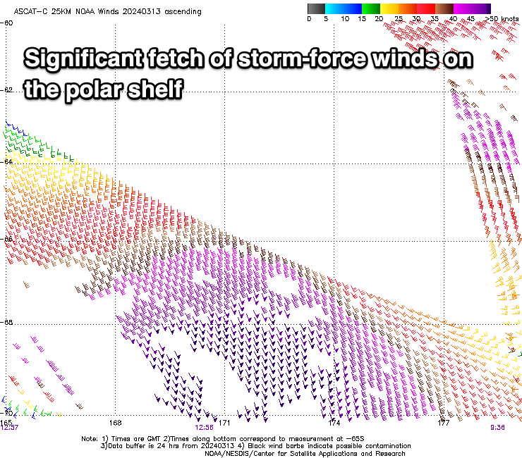
Looking at the satellite observations of the fetch generating the swell, and a broad swathe of storm-force S/SE winds were registered, with the swell due to reach the strong 4ft range across Clifton through later tomorrow afternoon and evening (smaller 2ft+ in the morning), easing back from 3-4ft on Sunday and 1-2ft Monday.
Locations down the South Arm exposed to the swell direction will be bigger and local winds will be best in the mornings. A light W/NW-NW breeze is due tomorrow, shifting SW and then S/SE while strengthening into the afternoon, N/NW tending E/SE and then E/NE on Sunday.
Monday should then see fresh N/NE winds, strengthening from the E/NE into the afternoon.
Into Tuesday, a new pulse of W'ly groundswell is due, generated by a strengthening low passing under Western Australia over the coming days. The fetch generating the swell will be in the western swell window, with a kick to 2ft due later in the day, easing from a similar size on Wednesday.
The morning will be best, ahead of the swell Tuesday with strong N/NE winds, shifting S/SW into the afternoon as the swell producing low moves east, with S/SW winds persisting Wednesday.
The end of the week looks slower but cleaner, though check back Monday for an update. Have a great weekend!