Building west swells over the period

Southern Tasmanian Forecast by Craig Brokensha (issued Wednesday March 6th)
Best Days: Friday morning, Saturday morning, Monday morning
Features of the Forecast (tl;dr)
- Weak W/SW swell for tomorrow with mod-fresh W/SW tending SW, then S/SE winds
- Peak in stronger W/SW swell Fri AM with variable tending S/SE winds
- Easing swell Sat with fresh N/NE winds
- Strong W/SW groundswell for Sun PM with NW tending SW then S/SW winds, easing Mon with N tending SE winds
Recap
Later Monday, a fresh pulse of large S/SE groundswell arrived, backing off from dawn yesterday with 4-5ft sets across exposed breaks and more size down the Arm.
The swell pulsed one final time through the mid-afternoon with sea breezes, then backed off from a clean but still fun 2-3ft this morning.
All in all a great run of swell to kick off autumn from the weekend through today.
This week and weekend (Mar 7 - 10)
The current S/SE swell energy will continue to fade tomorrow but a weakening frontal system moving in from the west should bring 1-2ft of new, weak W/SW swell.
Behind this, stronger levels of mid-period swell are due to peak Friday morning to 2ft to possibly 3ft, generated by the earlier stages of the progression which was much stronger and healthier.
Local winds with the passing front look dicey tomorrow and moderate to fresh from the W/SW, shifting SW ahead of S/SE sea breezes, with variable winds Friday morning ahead of sea breezes again.
Saturday will see fading, small 1ft to possibly 2ft sets and freshening N/NE winds will favour selected spots and bring in the heat.
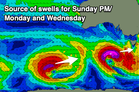
A low point in swell is due on Sunday and early NW winds will give into a SW tending S/SW change as a strong low clips the state.
Now, this low will generate a strong pulse of W/SW groundswell later in the day, easing through Monday.
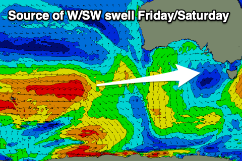
It’s expected to form south of Western Australia on Friday night and move through our western swell window but at strength, with a fetch of severe-gale to storm-force winds forecast.
With the low dipping east-southeast the swell will be west for the entirety, but likely kicking to 3-4ft across Clifton later in the day but with those onshore winds.
Monday looks the pick with N’ly winds and easing 3ft sets across Clifton, smaller again Tuesday.
Following the mid-latitude low, a stronger polar low looks to generate some reinforcing W/SW groundswell for next Wednesday but with onshore S/SE winds. We’ll have a closer look at this Friday though.