Fun swell pulses, best Friday morning and Sunday morning

Southern Tasmania Surf Forecast by Craig Brokensha (issued Monday 24th November)
Best Days: Wednesday morning, Thursday morning, Friday morning, Sunday morning
Recap
The weekend played out as planed with a tiny easing 1-1.5ft wave through Saturday and then near flat 0.5-1ft waves through Sunday morning. Today a slight lift in long-range W/SW swell should have been seen but not above 1ft or so.
This week and weekend (Nov 25 - 30)
We're looking at various pulses of W/SW tending SW swell over the coming period, the best this week filling in Thursday afternoon ahead of a secondary larger, strong pulse later Saturday, easing Sunday.
This will be related to initially a couple of weak cold fronts pushing up and across us over the coming days, but a better system projecting from the polar shelf up past us Thursday morning should generate the better SW swell.
A small W/SW pulse to 1-2ft is due through tomorrow, holding Wednesday with the better SW swell building to 2-3ft Thursday afternoon.
 Winds will unfortunately be onshore from the SW Thursday afternoon creating poor conditions.
Friday morning should be clean though as the swell eases from 2ft or so.
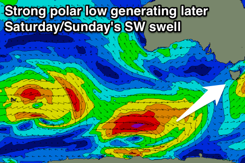
Saturday evening and Sunday morning's SW pulse will be generated by a vigorous polar low skirting around a strong high pressure system to our west, swinging in from the Southern Indian Ocean and then pushing along the Polar Shelf and then up towards New Zealand.
The swell should kick to a strong 3ft later Saturday and then ease from 2-3ft Sunday under less than ideal NE winds.
Longer term there's nothing too major on the cards, but we'll review this Wednesday.