Extended run from the south and southeast

South-east Queensland and Northern NSW Surf Forecast by Ben Matson (issued Wed 19th July)
Features of the Forecast (tl;dr)
- Easing trade swell into Thursday
- Strong S'ly swell building Thurs in NNSW (only small SE Qld)
- Easing S/SE Fri with early offshore winds, only small in SE Qld
- Strong though (generally) wind affected S'ly swell Sat, only small in SE Qld
- Light winds and strong E/SE swell Sun (biggest south from the Northern Rivers), easing Mon
- Plenty of swell for next week, though from the southern quadrant (so, staying generally small in SE Qld)
Recap
Pumping E/NE trade swells have provided 3ft+ sets throughout SE Qld and Northern NSW for the last few days (smaller on the MNC), with generally favourable morning winds tending S/SE throughout the day, ideal for arvo sessions on the outer points. A new S’ly swell is advancing along the Mid North Coast this afternoon, a little behind schedule and size only around the 3ft mark at south facing beaches, though we are seeing 5-6ft sets in Southern NSW at the moment (with more size to come). So it’ll trend upwards over the coming hours.
This week (Jul 20-21)
The current trade swell will continue to slowly ease through Thursday and with our focus shifting back to the south over the coming week, SE Qld surfers should try to make the most of anything you see later today or tomorrow, as swell production in our eastern swell window will close up shop for a little while.
Model data still suggests some 2ft+ sets at exposed SE Qld and Far Northern NSW beaches early morning but I’m a little dubious on size, strength and quality (so it may be smaller). Open beaches may also be a little ragged from the current S’ly flow that’s expected to persist for most of the night, but should ease back and swing to a lighter W/SW breeze just before dawn (exception here likely to be the Sunshine Coast).
As for south swell, it looks like we’ve got an upgrade in store for Thursday’s size across Northern NSW.
Today’s swell is trending up nicely across Southern NSW, and with the responsible low still very active in the southern Tasman Sea earlier today, we’re probably looking at a peak in the current swell cycle Thursday morning/lunch across the MNC, and lunch/arvo in the north, before easing into Friday.
There’s a few seperate swell sources too; in addition to a S/SW surge pushing up the eastern Tasmanian coast, there’s also a nice slingshot around the bottom of the low in the central Tasman, which should provide a little more SE in the swell direction at some point on Friday.
Aside from the aforementioned lingering S’ly winds on the Sunny Coast early Thursday, most locations should see light variable winds and afternoon sea breezes. South facing beaches are likely to reach 4-5ft south of Byron Bay on Thursday, with smaller surf elsewhere due to the direction.
North of the border, this S’ly swell won’t get into most beaches very well, maybe some 1-2ft sets though south swell magnets and exposed northern ends should pick up 3-4ft sets late in the day (maybe a little smaller on the Sunny Coast). Expect the morning to be undersized here, dominated by residual E/NE trade swell.
Friday will see size come down a little, from 4-5ft at south facing beaches in Northern NSW, (smaller elsewhere) whilst SE Qld will see 1-2ft waves across most of the outer points but up to 3ft at exposed northern ends and south swell magnets.
Friday’s conditions look unreal with light offshore winds and weak afternoon sea breezes. So it’ll be well worth a look around.
This weekend (July 22-23)
We’ve got a few swell sources for Saturday, though conditions look average with fresh SW tending S/SW and maybe S’ly winds on hand, thanks to a front pushing along the NSW coast.
This front looks pretty robust, and should contribute 3-5ft sets at south facing beaches south of Byron, however these locations will be wind affected. The shorter swell period and steeper S’ly swell direction (compared to the next few days) will also shave off a little more size than is ideal, so expect small options at protected slots. This includes SE Qld, which won’t pick up much new swell on Saturday - though there’ll be some easing residual surf from Friday in the water.
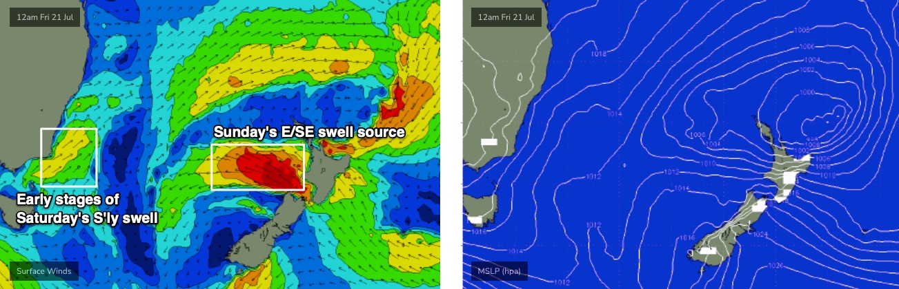
Sunday looks much better, with winds becoming lighter from the SW, and a brand new SE swell pushing through - of which we may actually see the leading edge push through late Saturday if we’re lucky.
This swell will have originated from gales exiting western Cook Strait (between NZ’s north and south islands) that are modelled to crop up from about Thursday onwards (see below). The fetch looks pretty good so I’m expecting a broad coverage of 4-5ft sets across much of the Mid North Coast and Northern NSW, though size will taper off in the Far North and SE Qld will see smaller surf up to 3ft+ at exposed spots, smaller running down the points. Let’s fine tune on Friday.
Next week (July 24 onwards)
Next week’s still looking pretty dynamic with a whole range of systems on the boil, though they'll all be out of the southern quadrant which won't favour SE Qld in the size department.
Easing E/SE swells from Sunday will persist through Monday (so, expect good waves at exposed beaches, especially south of the border), but lingering low pressure in the Tasman Sea looks like it’ll generate a few small fetches that’ll provide minor background S/SE energy through the first half of the week.
A strong front is modelled to push through the region early/mid week with the potential for a punchy S/SE groundswell around Wednesday and/or Thursday, while a mobile synoptic pattern in the Southern Ocean will ensure a continuation of long period S’ly swells for exposed spots.
So, plenty to look forward to - we’ve just gotta dial in the specifics, which we’ll do on Friday.
Comments
Congrats Ben!!
Erm....
hahahaaaaaaaaaaaaaaaaa
Best part is its only just starting.....well done mate! must be before hair went ......
If you were patient and a little bit lucky there were some screamers this morning.
Maybe some nudging 6ft on the takeoff.
Super fun in my hood, exposed spots pushing 4-5ft though a little smaller elsewhere, light offshore winds, warm blue water. Happy days.
Nice one Ben!
Yeah the buoy is showing 22.4 degrees, so couldn't be below 21 or so inshore.
Clear water, lots of baitfish.
Local shark guy reckons a 3m white swam under his boat this morning.
Big one sent me in around Ballina two days ago. Out by myself and it ended what had been a pumping arvo session in that fun NE swell. Were plenty of little spinner sharks around with all the bait in the water before the big fella turned up.
Hi all, I don’t understand why some beaches are overpowered and some not. Similarly with points, some are perfect till 3-4ft and become mush above that- would you mind sharing knowledge on what are the marine topography features that allow a spot /bank to continue to work with big condition and vis -versa?
My understanding is bathymetry is the big one, which can include the gradient and shape of the ocean floor approaching the break, sand and its alignment in the wave zone. For example, the little brother to NNSW's premier point break, sometimes will hold 6ft of swell from the south or east, sometimes will be garbage in 4ft and a burger. Very sand dependent there but has the underlying features to be amazing, sadly doesn't seem to do that too much the last few years.
I reckon Swellnet could do worse than having previous tech articles easily available (just for subscribers?) and categorised for reference.
Whaddya reckon Ben?
Yeah they're all here - but I agree, we need a better categorisation.
https://www.swellnet.com/news/swellnet-analysis