Northerlies to persist until Sunday; plenty of options next week

South-east Queensland and Northern NSW Surf Forecast by Ben Matson (issued Monday 8th January)
Best Days: Fri: chance for a window of small beachies early morning from a brief SE swell, mainly in Northern NSW. Sun: small clean beachies with offshore winds.
Recap: The weekend saw very small surf, mainly small residual energy Saturday, a small flush of long period S’ly swell overnight Saturday (argh!) and then a late arrival of small SE swell Sunday afternoon across Northern NSW that had largely disappeared by this morning. And now the northerlies are up.
Today’s Forecaster Notes are brought to you by Rip Curl
This week (Jan 9th - 12th)
Wow, we've got another terrible week of surf ahead.
The protagonist is a stationary high in the northern Tasman Sea that’s riding more north in latitude than is expected at this time of the year. As such the ‘trades’ (though they are climatically weak right now anyway) are positioned north from about New Caledonia, so our easterly swell prospects are minimal for the short term.
Check the chart below for Coffs Harbour - we have five more days of N’ly winds on the cards (SE Qld will actually see six, thru’ Sunday). Sure, they’ll back off Wednesday and Thursday as a weak trough slides up the coast, but without any new swell in the water (save some minor local windswell) it’s very hard to get enthusiastic about our surf prospects.
Winds will be lighter as you head north from Coffs, though again we’ll really struggle for anything worthwhile. Some exposed beaches throughout SE Qld - mainly the Sunny Coast - may pick up small spread of energy emanating from the Coral Sea trades but it’s poorly aligned and win’t have much strength (or size). You’re really better off disregarding the coast for a few days.
There is one potential window of opportunity though. The parent low to the weak trough due Wed/Thurs will concurrently develop in the central Southern Sea, slowly tracking E/SE towards the southern end of New Zealand. It’s expected to reach maturity through the middle of Wednesday, developing a broad though relatively short lived SE fetch.
Its alignment for Southern NSW is good, but a little less so for Northern NSW and it’s not ideal for SE Qld at all. Worse, it doesn’t hang around for long enough to generate any meaningful size (and the E/SE forward track doesn’t help either). But we should see a small flush of swell from it.
At this stage this new swell is due to arrive across the Mid North Coast just after dinner Thursday, pushing northwards overnight before slowly easing through Friday. Therefore, Friday morning should see some stray 2ft, perhaps 2-3ft sets (if we’re lucky) at south swell magnets south of Byron Bay, with smaller surf to 2ft on the Tweed Coast and then 1-2ft at exposed northern ends of the Gold Coast, marginally smaller again across the Sunny Coast. Most SE Qld beaches and outer points will be even smaller.
However, it’s also worth noting that a minor, temporary intensification of the trades south of new Caledonia later Wednesday may provide a small pulse of E/SE swell for SE Qld and Far Northern NSW beaches on Friday, though we won’t see much than a weak 1-2ft at most spots. And it'll be very slow going.
N’ly winds should be very light Friday morning, and we may see a few regions blowing NW, but you’ll have to be on it at dawn to maximise your chances as the breeze will freshen by mid-morning.
So, there’s your best window of the week. Other than that, it looks shocking.
This weekend (Jan 13th - 14th)
Saturday looks tricky, but ultimately low value for surfers. We have no new swell sources on tap, just some small residual SE swell from Friday plus a small trade swell across SE Qld and Far Northern NSW.
Reliable swell magnets will struggle to see much more than the odd 2ft set, and northerly winds are likely to create problems at most beaches (though an early window of NW winds are possible across SE Qld). We may also see a building NE windswell across the Mid North Coast into Saturday afternoon up to 2-3ft, but quality will be hard to find.
A pre-frontal trough will swing winds from the NW to the SW across the Mid North Coast on Sunday, ahead of a late gusty S’ly change that’ll eventually slide up the region overnight and dominate the region into Monday. Winds will remain N/NW across SE Qld and Far Northern NSW but should trend more NW throughout the day.
Sunday’s waves will consist of easing NE windswell across the Mid North Coast plus a small level of trade swell elsewhere. Wave heights should hold out around 1-2ft at most beaches from this source; the trade swell may punch slightly higher throughout the day but mainly across SE Qld. It will be rather slow and inconsistent though.
Overall, we’re likely to see some small beachies in most areas but it won’t be very large.
Next week (Jan 15th onwards)
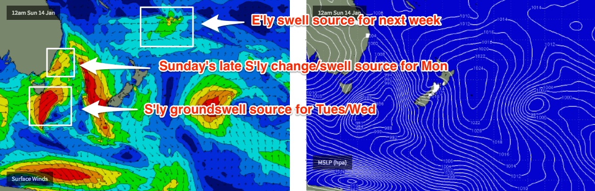
A broad trough of low pressure west of Fiji later this week is expected to slowly push south into the weekend, squeezing an E’ly fetch between it and generating a slow increase in trade swell for our region next week. This will gradually materialise at the coast over the weekend but it won’t reach a peak until later Tuesday, Wednesday and Thursday when we’ll see sets pushing 2ft to maybe 2-3ft at exposed beaches.
By this time, the surf zone will have a couple of other sources in the mix too. Sunday’s late change will drive a ridge through the Coral Sea and we’ll see some short range SE swell across Far Northern NSW and SE Qld beaches on Monday as a result.
Additionally, a series of intense Southern Ocean lows look like they’ll provide some welcome southerly groundswell across Northern NSW early/mid next week.
A bombing low south of Tasmania from Friday will initially be poorly aligned (and tracking too quick to the south) to favour surf for Southern NSW, but a later incarnation of the same system as it stalls of the Ice Shelf over the weekend will generate better (though only small) long period S’ly swell that’s due in around Tuesday.
However, a more significant system will cross the Tasmanian region early Sunday morning - the parent low to Sunday’s change - and this, plus a series of strong secondary fronts trailing behind - will maintain plenty of moderate south swell from Monday thru’ Wednesday at least. And fortunately for surfers south of about Yamba, local winds look pretty good under a high pressure system.
Let’s initially flag size peaking around the 3-5ft mark at south facing beaches south of Byron (say, Tuesday or Wednesday), and revise over the coming days. It’s doubtful that these south swells will make an impact north of the border though, so we’ll be reliant on the trade swells(s) for next week’s energy.
Comments
The surf may be utterly uninspiring but a predawn head out up the Pacific highway still has to be one of life's most subtle pleasures.
Having the road to yourself and the cicadas are going nuts before the suns poked its head above the rim. A coffee and a Scoob and then it's all cane fields , blue skies and big rivers.
A few hours in and it's time to top up the coffee buzz in a picturesque little Aussie beach town. Neil Diamond croons through the cafe speakers as the first kids start hitting the fun turbos on the swings in the park next to the river.
Never surfed it myself but where that river meets the sea there must be some kind of wave. Probably a right but on its day there might be all kinds of lefts !
Few hours on the road yet.
Enjoy the ride.
Where ever you are.
Thats it Blowin, you've inspired me.
I'm loading up the wagon and taking the kids to Ballina.
Seeya at the Big Prawn.
If the prawn had mouse ears there'd be not a single reason for anyone to go to Disneyland.
I'm north of the Prawn....but not by much .
What's next ?
The pineapple ?
.
Fun Little wave on the goldy this morning, Chest high on the take offs, super clean just before the low, enough to satisfy the appetite.
Chest high? That's a bit of a surprise based on surfcams.. looks barely a foot at most beaches. I presume you were on the northern end of the coast (wind is NW).. Narrowneck cam looks tiny though, it's just a shorey.
I'm only 5'8, lol, on the sets yes. The surfcams sometimes don't do it justice, yep north of the neck.
I'm trying to be coy, hoping there is a little jump for tomorrow morning. Don't want to turn up & a full crew on it.
Unreal.. must be some of that small trade swell pushing down from the Coral Sea, though I wasn't expecting very much size at all.
There's miles of empty beachies up that way too, so very little chance of having your session spoiled.