Large, windy surf over the coming days: points only!

South-east Queensland and Northern NSW Surf Forecast by Ben Matson (issued Monday 12th June)
Best Days: Protected points for the entire week, but biggest late Tues and Wed with a solid SE swell and gusty winds.
Recap: We’ve seen plenty of swell over the last few days with some impressive rainfall totals too. Conditions were quite windy on Saturday and surf size was initially undersized in SE Qld, but it built throughout the day and held in around 4ft north of the border on Sunday. South from Byron, we’ve seen 4-6ft sets at exposed south facing beaches though conditions haven’t been great due to the wind and rain. Today, the Sunshine Coast has pegged back a bit in size but the Gold and Tweed Coast seem to have levelled out with size still around 3-4ft, and south from Byron open beaches are around 4-5ft, with much better conditions as winds swing offshore.
This week (Jun 13 - 16)
There’s no shortage of swell ahead!
The trough off the coast is expected to re-intensify into a low over the coming 24 hours, and track west back into the mainland, strengthening strong to gale force winds about the coastal margin.
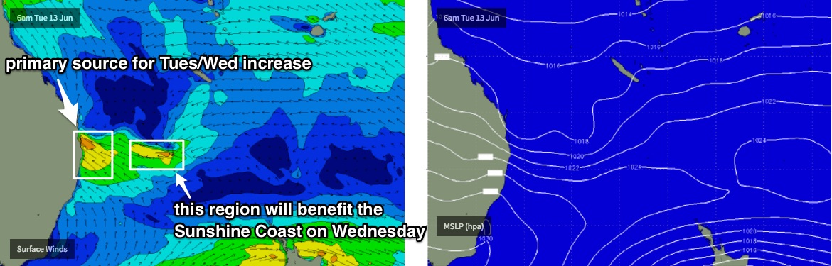
Interestingly, this fetch will be initially aimed into Far Northern NSW and the Gold Coast, however the Sunshine Coast may be at first partially shadowed from the bulk swell (by Moreton/Stradbroke Islands, and also the slightly southern position of the fetch). Wind strength should be lighter (not much, but enough) south of about Yamba or Coffs.
However, at the same time we’ll see the fetch broaden back out into the Coral Sea. My take on this is that it’s this secondary factor that will probably benefit the Sunshine Coast the best, but maybe not until Wednesday.
So, Tuesday should see a rapid increase in size across most areas - with a lot of wind - but the Sunny Coast may initially dip out slightly the size department, with a smaller increase than its southern counterparts. Winds will be S’ly tending SW across the Sunshine Coast, whilst locations further south from the Gold Coast will see early S/SW winds tending S’ly then gale force SE.
Wednesday will simply be large and windy everywhere with strong to gale force SE winds. There’s very little chance of early SW winds, possibly the southern Gold Coast at best.
As for size, expect exposed beaches be pushing well north of 6ft+ from about lunchtime Tuesday through most of Wednesday. Slightly smaller surf is likely on the Sunshine Coast on Tuesday, and also south of about Coffs too (as the fetch won’t be as well aimed toward the Mid North Coast) ahead of a solid peak on Wednesday.
However with these winds the only options anywhere between Seal Rocks and the Noosa Head will be sheltered points, which will be much smaller in size.
From then on it’s a steady easing trend through Thursday and Friday with abating winds from the southern quadrant. However it won’t be small by any stretch - still 4-5ft across SE Qld beaches on Thursday and 4-6ft around Northern NSW (though horribly wind affected at most open spots). Sheltered locations will still offer the best, though smaller options.
Smaller surf is then expected on Friday, still enough for the outer points in SE Qld to offer worthwhile opportunities.
Also worth noting is a series of southerly groundswells due over the coming days. Initially they’ll be small and uninteresting, however one final swell is expected very late Wednsday (Lower Mid North Coast) and through Thursday (everywhere else) that should produce occasional 3ft+ sets at south swell magnets south of Byron. I doubt it’ll be distinguishable between the local noise though.
This weekend (Jun 17 - 18)
A broadening high in the eastern Tasman Sea and a developing coastal trough running the length of the East Coast later in the week will set up a modest E’ly fetch south of New Caledonia that should maintain small peaky E’ly swells for the weekend. No great size is expected but most beaches should see reasonably consistent 2ft waves both days, maybe 2-3ft at exposed beaches.
There’s also be some small short range S’ly swell in the water on Saturday - mainly south facing beaches south of Byron - thanks to a fresh local fetch around the western flank of the developing trough later this week. It won’t be much of a quality contributor though.
Moderating SW tending S’ly winds Saturday should become light and variable on Sunday.
It’s also worth nothing that the current troughy pattern is pretty unstable, and as per what we saw for much of last week, we’re likely to see some significant revisions in the model output over the coming days. So don’t be surprised if the forecast for the end of this week and the weekend has another curveball aimed in its general direction.
Next week (Jun 19 onwards)
An amplifying node of the Long Wave Trough across our south swell window on Sunday is expected to kick up a strong south swell early next week. It’s still along time away - and keeping in mind that the end of the model runs have been quite ‘explosive’ for the last few weeks - so we need to take this outlook with a grain of salt.
However it does look like we’re in for an extended run of sizeable surf for much of next week, mainly in Northern NSW though if the swell becomes quite larger we should see some small translation into SE Qld.
I’ll also be keeping a close eye on the model’s projections of the eastern flank of the Tasman trough over the weekend (prior to the LWT activating strong southerly winds early next week).
At this stage a developing E/NE fetch in the central Tasman Sea during this period looks impressive as individual snapshots (mainly for the Mid North Coast), but as a sequence is moves too fast, and too far SE to benefit swell production for much of NSW. It doesn’t take much of a tweak in the model guidance for things to move back in favour for us though, so let’s investigate in more detail on Wednesday.
Comments
Brown and drizzly, but otherwise delicious. Greeny and Currumbin this arvo.
Meanwhile, the Sunny Coast is living up to its namesake. Alex ain't very big though, and it's pretty small at Noosa too.
Coupla..
You guys should add option to upvote
Sick
Shame the swell has been really straight on the Sunny Coast open beachies. Nice conditions otherwise.
It ain't offer 4-5ft Snapper under a southerly wind results in an empty lineup.
The sweep must be horrendous.
Meanwhile, down the bank...
And up on the Sunny Coast:
Oh lordy.
How's the entry! These blokes were standing here for a while.
That bank really is super...
Wind gusts of 51kts SSE at Cape Moreton.