Trade swell for the coming days; fun combo of S swells for Friday and Saturday

South-east Queensland and Northern NSW Surf Forecast by Ben Matson (issued Monday 20th March)
Best Days: Fri: building combo of south swells and a small residual trade swell, biggest and best south of Byron with mainly light winds. Sat: easing combo of S and SE swells south of Byron, and early light winds.
Recap: There's been plenty of surf over the last few days. Saturday afternoon and early Sunday peaked around the 6ft+ mark across the Mid North Coast, with incredible rainfall totals and driving onshore winds. These conditions affected Northern NSW up to about Evans Head (which picked up 83mm of rain in an hour Saturday morning!) but winds were light offshore on Saturday morning north from here through the SE Qld region, ahead of freshening NE sea breezes into the afternoon. Winds broadly remained mainly N/NE on Sunday, though the Gold Coast - fortunately for the Quiksilver Pro - saw light, localised variable winds for much of the day, and subsequently clean-ish conditions. Surf size maintained 3-4ft on Saturday morning throughout the Tweed and Gold Coasts, and increased to 3-5ft on Saturday afternoon, holding this size range through Sunday, with slightly smaller surf on the Sunshine Coast (and slightly bigger surf across the Ballina coast). Sunday's small region of light winds in SE Qld shifted to the Sunshine Coast morning, which enjoyed three hours of early offshores whilst the Gold Coast and most of Northern NSW saw moderate to fresh E/NE winds (winds have been up from the NE on the Sunny Coast today though have recently gone variable again). Wave heights are easing but still holding 3-4ft at most open beaches, a little smaller across the Sunshine Coast.
This week (Mar 21st - 24th)
Our primary swell generating system right now is a broad ridge through the Northern Tasman Sea. It’s expected to weaken very slowly over the coming days, and in doing so will bring about a gradual drop in surf size through the middle to latter part of the week.
If anything, the ridge is deeper and more established into the southern Coral Sea than what was expected on Friday, so we should have relatively uniform size distribution between the Sunshine Coast and the Mid North Coast by Tuesday, holding into Wednesday with set waves around the 3ft+ mark at most open beaches. The Mid North Coast will see an easing trend from Wednesday onwards (Thursday onwards north of Yamba). The swell will be short range and peaky in nature thus favouring the open beaches.
The ridge is driving NE winds across southern locations, tending more E/NE across northern locations (i.e. SE Qld). So conditions won’t be great, but there’s scope for isolated regions of light variable winds in and around microscale low pressure systems (which can’t be accurately forecast to any specific region, unfortunately). You’ll just have to keep an eye on things and pounce when the window opens up.
Winds will veer more to the N/NE on Wednesday; it shouldn’t be too strong across SE Qld - enough to create unwelcome bumps but not totally destroy the waves - but it will be stronger south of Ballina or thereabouts. So you’ll have to tuck into a sheltered northern corner across much of Northern NSW, particular in the south.
Easing E’ly swells will then pad out Thursday and Friday. A developing Tasman Low in the Southern Tasman Sea on Wednesday will push a southerly change across the Mid North Coast on Thursday, reaching SE Qld on Friday though the latest models have significantly weakened this system.
So I’m not expecting much influence locally from this change - winds should be light for much of Thursday and Friday in SE Qld - Northern NSW should see temporarily gusty conditions as the cange passes through on Thursday afternoon but it’ll become light again on Friday.
As for surf potential - the low will also generate a new S/SE tending SE swell though a short fetch length will limit surf heights - a shame too, as the low will develop in a great part of our mid-range SE swell window, and will display good speeds of 30-35kts+ at its core.
This new swell is expected to build through from late Thursday across the Lower Mid North Coast, reaching most of Northern NSW into Friday, and then holding into Saturday. Set waves should push into the 3-4ft range at south swell magnets south of Byron, though it’ll be smaller elsewhere with just some minor residual trade swell around 1-2ft. Note, this south swell estimate is higher than what our automated model is expecting (2-3ft) and there's a chance for an upgrade if the low stalls and strengthens in the Tasman Sea.
North of Byron, I’m not expecting much size from this Tasman Low across SE Qld on Friday, just a foot or two at open beaches, with a few 2ft+ sets at south swell magnets. There’ll be a comparable level of residual trade swell in the water.
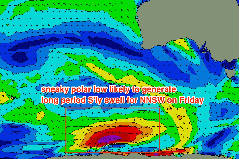
Also in the water from on Friday will be a small long period S’ly groundswell, generated by an intense polar low that tracked under Western Australia over the weekend. It was positioned an enormous distance from the Australian East Coast, and also tracked outside the periphery of the swell window, however we should see some influence from the latter stages of this low (beneath South Australia, today) as it skirts the ice shelf.
At this stage I’d be surprised to see much more than extremely inconsistent 2-3ft sets at south swell magnets south of Byron - which is less than what I’m expecting from the Tasman Low - so being very infrequent, they’ll be hard to discern beneath the mix. But it’s worth detailing this swell in the event that the models go haywire on the Tasman Low over the coming days (unlikely, but possible).
So, Friday is the pick of the forecast period with a blend of two south swells and a small trade swell, plus light winds just about everywhere. Aim south of Byron for the most size.
This weekend (Mar 25th - 26th)
Looks like the Tasman Low will slowly weaken and swing clockwise, away from our swell window through Friday and into Saturday. This will lead to a slow decrease in SE swell over the weekend.
A redeveloping coastal trough across Southern NSW will slowly freshen NE winds, though no great strength is expected at this stage. So conditions should be OK both days, though there is a risk that we’ll see future model updates pick up the projected speeds. The models also have an anomalous S’ly change across the Mid North Coast for Sunday afternoon but I think this is just a weird aberration owing to the troughy pattern, and it won’t last through many model updates.
As for size, Saturday morning should hold somewhere around the 3ft+ mark at south facing beaches south of Byron (smaller elsewhere), before easing to 2ft on Sunday. Expect smaller surf north of the border, only suitable for the wide open beach breaks.
Let’s see how thing are looking on Wednesday, but at this stage Saturday morning looks to be the pick of the forecast period.
Next week (Mar 27th onwards)
Nothing amazing standing out in next week’s forecast at this stage, with only local swell sources on the cards foe early next week as a NE airstream builds across the coastal margin.
Comments
Still waiting for Noosa to fire up this year.......it's been the worst year ever.Think the swell is waiting for Easter to kick in...
Thats the funniest comment I've heard for ages
I've been sitting in Byron Bay surfing ESE, SE, NE and S Swells waiting for Noosa to turn on. Alas climate change ( Used to ave 18 cyclones a season ) has changed all that. Surfers adapt pretty quickly. I've seen more QLD surfers in Nth NSW than ever before. C U in another life time NOOSA.
18 cyclones a season ?
Could be #1 of the season over the weekend/early next week. Certainly something to keep an eye on up north as the charts are progging some possible developments. MJO not overly strong though so I'm not highly confident.
Wow latest EC has a serious cyclone forecast along with flooding rains as she moves across Qld and into NT.
I think we'd all rejoice if the GEM track (yellow) came to fruition!!!
http://www.tropicaltidbits.com/storminfo/91P_tracks_latest.png
My boards are on gumtree, and I'm going to give golf a go.
Let's start talking about grass and stuff !!
The Earthquake in Bali felt strong this morning got woken up eveything shaking.
I'll say....first one I have felt. Kind of surreal actually
An observation re' eastern swell window... The few rare lows/dips that have formed during this very below average season have all seemed to be nnw of a potential "cradling high", moving sw, which is far from optimum. Directly above the high, or even nne of the high creates the perfect cradle and squeeze.. But this year, it seems the high has already moved too far east, and the low seems to slip down and around the high from 12 oclock to 9 oclock into a slack zone where it loses oomph... A perfect example of this can be seen in gfs forecast for march 30 onwards. Note tropical low potentially forming out at 165w 20s.... It sw movement is good when a high can cradle it, but the high is already way too far out to the east.... Seen this a few times this year....