Plenty of S/SE swell all week

South East Queensland and Northern New South Wales Surf Forecast by Ben Matson (issued Monday 25th May)
Best Days: Tues: strong S/SE swell building across the coast (small in SE Qld), with light winds. Wed: easing S/SE swell with light winds. Thurs: small and clean in Northern NSW. Fri: interesting SE swell but best suited for the Mid North Coast (may be only small north from about Yamba).
Recap: Lots of south swell over the weekend, with large waves in Northern NSW and considerably smaller surf across SE Qld. Smaller waves today but still plenty of lines across at exposed beaches.
This week (May 26 - 29)
We’ve got some great waves ahead, especially if you live in Northern NSW. A new S/SE groundswell is marching up the coast and should be in the water across the Mid North Coast early Tuesday morning, reaching the Far North Coast and SE Qld coasts after lunch (prior to then, we’ll see similar residual S/SE swell as per today).
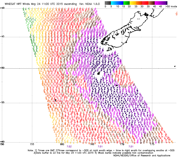 The weather system responsible for this new S/SE swell performed impressively over the weekend, recording S’ly winds of 50-60kts immediately south of New Zealand (see right). Although this is not very well aligned within our swell window, we will still see a considerable pulse of sideband energy from it throughout Tuesday.
South facing beaches in Northern NSW will see the biggest waves - somewhere in the 4-5ft+ range at times - and conditions should be clean with mainly light variable winds. Expect smaller surf at locations not open to the south, however bigger waves (6-8ft sets) are likely at some of the more reliable south swell magnets due to the large swell periods (likely to be in the 17-18 second range). To be honest I wouldn't be surprised if we saw slightly bigger surf than this - mainly due to the sheer strength and coverage of the core fetch - but it's a difficult weather system to have confidence in so I'm going to peg back my expectations.
In SE Qld, wave heights will taper off as the swell refracts back into the coast but we’re still looking at some good waves in general. Most Gold Coast/Sunshine Coast beaches should see an afternoon peak into the 2-3ft range, with semi-exposed points likely to see 3-4ft sets at times. The region's handful of south swell magnets should reach 4-5ft+ by the end of the day and similarly light winds are also expected here. It will however be smaller in the morning before the new swell arrives (keep an eye on the surfcams for signs of life).
Tuesday’s swell will then ease slowly through Wednesday with light variable winds maintaining excellent conditions just about everywhere. A further small drop is likely into Thursday, and conditions will remain excellent as a series of fronts approaching from the west steer local winds around to the NW in Northern NSW, with variable winds in SE Qld. Most open (south facing) beaches should still see 2-3ft sets though, with smaller waves at remaining beaches and also across SE Qld.
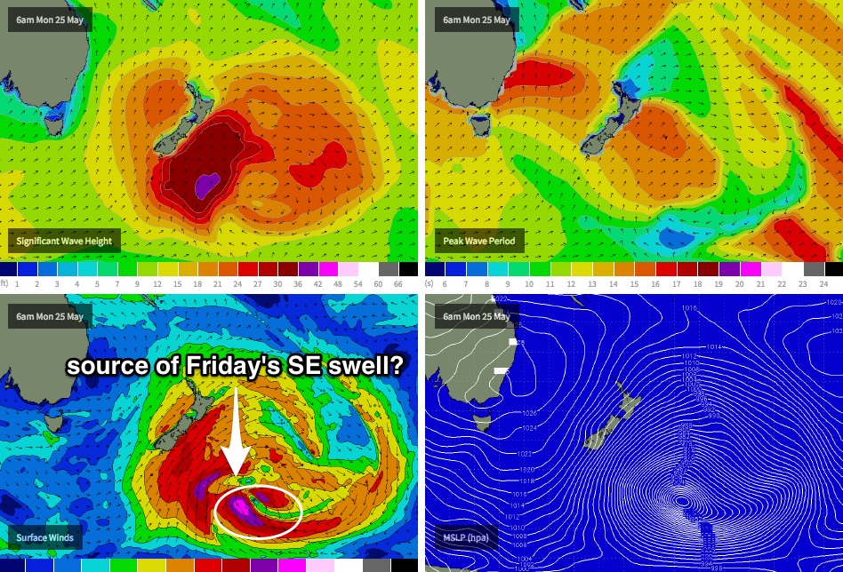
Friday has some really interesting possibilities for the southern regions, originating from a very rare part of our swell window. The intense low pressure system now south-east of New Zealand that’s responsible for Tuesday’s S/SE swell is expected to merge with another deep low pressure centre overnight tonight, just to the east (see chart below). Storm force E/SE tending SE then S’ly winds feeding into this system are expected to briefly show strength in our remote SE swell window - right on the other side of New Zealand - and I think we’ll see a pulse of long range SE groundswell arrive on Friday morning from this source.
However, due to the swell shadow offered by New Zealand’s South Island, wave heights are likely to become smaller with increasing northerly latitude - essentially the reverse of what we experience from east swells (along the Northern NSW coast) when tropical depressions slip south into the swell shadow of New Zealand’s North Island.
As such, we’ll probably see a good pulse of SE swell across the Mid North Coast but I am doubtful that there’ll be as much size on offer north of about Yamba (give or take). For now let’s aim for clean 2-3ft+ surf at open beaches across the Mid North, with smaller surf to the north. Our remaining swell windows will be inactive through the second half of the week so this is our only source of energy for Friday. I’ll reevaluate on Wednesday in more detail.
This weekend (May 30 - Jun 1)
Nothing amazing is expected for the weekend at this stage. The Southern Ocean storm track looks like it’ll be mainly aimed away from our swell window; we have a few small pulses of south swell on the cards but no real size is expected.
Friday’s SE groundswell should still be with us early Saturday morning but it’ll be trending quickly downwards during the day - I don't think there’ll be much more than a very inconsistent 2-3ft at exposed beaches across the Mid North Coast early on, with smaller waves north of here and into SE Qld.
Otherwise, we’re not expecting any other new swell for SE Qld for the rest of thew weekend and Northern NSW will see just some small S’ly energy from poorly aligned frontal systems crossing the Tasmanian region later this week. Hopefully the models will upgrade the weekend outlook into the coming days.
Next week (June 2 onwards)
A deepening trough north of New Zealand from Friday onwards looks set to generate a small E’ly swell for us early next week. No major size is expected but we should see a few small waves at open beaches in the 2ft+ range from Monday afternoon through until about Wednesday or thereabouts.
Elsewhere, with the Long Wave Trough expected to remain slow moving to the west of Tasmania for most of the forecast period, it may not be until the middle of next week where it clears into the Tasman Sea’s swell window and we can anticipate a stronger renewal of southerly swell for the second half of the week. Until then, our primary south swell window looks like it’ll remain a little inactive. More on this in Wednesday’s update.
Comments
Hmmmm, that super long range (16-17 sec) S'ly swell appears to either be running late and/or below forecast expectations? Multi-spectral now showing the dominant swell energy in the 16-17 sec band?
not at all Don. It was in the water this morning.
Not disputing it wasn't/isn't in the water. Just doesn't look to the dominant energy at present, looking at the Byron and even buoys to the south.
What buoy are you looking at? Byron seemed to pick up 18sec+ energy around 9am but the bulk swell energy (ie most size) would be located further back in the 15-16 second range (which isn't expect north of the border until this afternoon). Certainly solid in Southern NSW this morning - although very inconsistent - IMO this swell was probably aimed better at Northern NSW (albeit with a larger travel distance than Southern NSW).
Byron Ben, but even the Crowdy head isn't showing it as the dominant energy.
But LOL, just as I write this Byron buoy now showing it as the dominant energy.
Good call Ben. Byron buoy confirming your arvo forecast time.
That WAM is showing off - that low off the East Coast NZ is outrageous! Whats the hectopascal down too?
Byron Buoy is unreliable as far as translating pure buoy data to inshore wave heights. It's drastically contaminated by prevailing sea state, especially under S swell conditions.
There was really good quality long period SSE swell in the water all day.
Yet the surf dropped in size through the arvo, was way bigger this morning.
Was very interesting surfing a beachie with 13-15sec period swell this morning. Certainly some added grunt approaching the mid morning low tide!!
Still have water draining out of my nose every time I bend over!!!
How big Don? Looked very small on our surfcams this AM.
Not where I was this morning Ben. 3ft with the very odd freak set close to 4ft early dawn. But very very long waits for these. Bathymetry playing a big part as got reports it was a mixed bag of size range along various parts of the coast.
Ben i'm heading to Fiji tomorrow till the 6th just trying to work out when i might be able to get to surf cloud break/restaurants when the girls are on a lay day or if there will be enough swell for them to run it quick and get it finished???
thanks
Dazz, the Cloudbreak forecast page here says it all (although, typically undercalls wave heights by a foot or two, sometimes more if it's a very long period swell.
http://www.swellnet.com/reports/south-pacific/fiji/cloudbreak/forecast
Interestingly, the weekend looks like it'll pick up some long period swell from the weather system SE of New Zealand (swell periods around 15-16 seconds Saturday from about 175 degrees, i.e. just SE of S) although I've never heard of Cloudbreak benefiting to a major degree from this source region (really prefers a SW swell direction). So while there'll be plenty of waves the swell direction may cause it to break differently.
Craig's more up to speed with what's happening in Fiji but the overall trend looks slowly down from tomorrow through until Monday, ahead of a slow building trend all of next week (and getting pretty sizey around Friday and Saturday). Conditions look reasonably good for the next few days, then excellent from Monday thru' the middle of next week at least.