Tricky winds with plenty of swell

South Australian Forecast by Craig Brokensha (issued Monday March 18th)
Best Days: Today South Coast, tomorrow morning South Coast for the keen, Mid Coast Wednesday and for the keen Thursday morning, South Coast Thursday morning and for the keen Sunday morning but more so Monday morning and early Tuesday
Features of the Forecast (tl;dr)
- Moderate sized W/SW groundswell building tomorrow, easing Wed
- Mid-period W/SW swell also in the mid Wed, easing Thu
- Fresh W/SW tending stronger SW then S/SW winds tomorrow (W/NW in the AM down South)
- Gusty S/SE winds Wed
- Easing swell Thu with E/NE tending S/SE winds
- Smaller Fri with moderate SE tending S/SE winds
- Moderate sized, mid-period S/SW swell building Sat, holding Sun/Mon
- Fresh SE tending S/SE winds Sat, moderate E/SE tending S/SE Sun, E/NE-NE tending S/SE Mon
- Moderate sized S/SW groundswell Tue with early variable tending strong S winds
Recap
The South Coast magnets offered great options most of the weekend, biggest Saturday morning with a mix of swells, smaller into yesterday while the Mid Coast came in tiny to flat.
Today the surf was again small down South and to 2ft with a background S/SW swell, flat on the Mid Coast.

Clean, small waves today
This week and weekend (Mar 19 - 24)
The week ahead is flukey wind wise for the South Coast with cleaner conditions due in the gulf with a couple of small pulses of swell.
Looking at tomorrow, and a moderate sized pulse of W/SW groundswell is due to fill in, generated by a healthy fetch of gale to severe-gale W/NW winds forming around a low, to the south-west of Western Australia on the weekend.
Unfortunately the remnants of the swell generating system will clip us tomorrow, bringing a strengthening W/SW tending SW then S/SW change. This will create poor conditions as the surf builds to 2ft on the Mid Coast, and 4ft across Middleton. The morning looks cleaner down South with a W/NW offshore but smaller 2ft+ waves.
Wednesday will become cleaner inside the gulf as winds shift S/SE and hold all day, along with some reinforcing mid-period W/SW swell that should maintain 2ft sets on the favourable parts of the tide in the gulf, but ease from 4ft across Middleton.
Come Thursday, the surf will ease with fading 1.5ft+ sets on the Mid Coast, 3ft+ down South and with a shift in winds to the E/NE down South (E/SE across the Mid Coast), ahead of S/SE sea breezes.
Friday looks to be a lay day with smaller surf and less favourable SE winds in the morning, freshening through the day from the S/SE.
The weekend will unfortunately see winds persist out of the south-eastern quadrant as a high sits to our south-west, with a slight improvement due on Sunday as winds tend more E/SE in the morning.

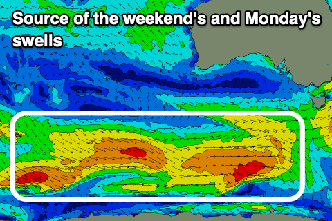
Swell wise, a healthy progression of frontal systems moving under the country this week (above left) should produce fun levels of moderate sized S/SW swell from Saturday afternoon through Monday.
The swells look to be in the 3-4ft range across Middleton but tiny in the gulf, with a stronger pulse of S/SW groundswell likely next Tuesday. This will be thanks to a stronger low generating gale-force winds on the tail of the progression, with surf to 4-5ft likely next Tuesday morning down South.
Winds are expected to improve early next week, swinging E/NE-NE on Monday morning and possibly variable early Tuesday morning before a trough brings a return to S'ly breezes. The models diverge a little regarding this so we'll have to have a closer look at the outlook for next week on Wednesday.