Small, fun weekend, with a new swell next week but with poor winds for the South Coast

South Australian Forecast by Craig Brokensha (issued Friday March 15th)
Best Days: South Coast tomorrow morning, Sunday morning and Monday morning for the keen, Mid Coast Tuesday afternoon and Wednesday
Features of the Forecast (tl;dr)
- Small, easing mix of swells tomorrow with variable NE tending E/NE winds ahead of SE sea breezes
- Smaller Sun AM variable N-N/NE tending E/NE winds ahead of SE sea breezes
- Small, flukey mid-period S swell Sun PM, easing Mon
- N winds Mon AM, tending S/SW into the PM and strengthening
- Fresh S'ly winds Tue, strengthening from the S/SE
- Moderate sized W/SW groundswell building Tue, easing Wed
- Strong S/SE-SE winds Wed, E/SE tending S/SE Thu
Recap
Poor conditions across the South Coast yesterday only for the desperate, a little more workable this morning with an E/SE breeze and swell holding the 3ft range. The Mid Coast has been tiny and to 1ft yesterday, near flat but not quite today.
This week and weekend (Mar 16 - 22)
Looking at the weekend ahead, and we've got generally, small, weak surf, with a kick in S/SE windswell due this afternoon expected to ease back through tomorrow morning from 2ft+, smaller and 1-2ft on Sunday morning.
A small pulse of mid-period S'ly swell may be seen Sunday afternoon, but the frontal system generating it has formed super late in our swell window, south-west of Tasmania. With this I wouldn't expect much over 2ft+, easing from 2ft Monday. The Mid Coast will remain tiny to flat.
Local winds should be variable and NE tomorrow morning, tending E/NE then S/SE, with Sunday seeing N-N/NE winds, before tending E/NE and then S/SE again into the afternoon, but without any major strength.
N'ly winds should persist Monday morning as the small swell eases, shifting S/SW early afternoon and becoming gusty as a trough moves in from the west.
Now, this change will be associated with a strong low moving in from the west, bringing a moderate + sized W/SW groundswell for Tuesday. This will also be with fresh S'ly winds, strengthening from the S/SE as high pressure starts to edge in from the west.
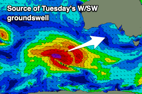
Coming back to the swell, and it'll be generated by a fetch of gale to severe-gale W/NW winds forming on the northern flank of the developing low, south-west of Western Australia.
It's due to build through Tuesday and peak into the late afternoon/evening with the Mid Coast building to 2ft on the sets, easing from a similar size Wednesday (on the favourable parts of the tide), with Middleton pulsing to 4ft+, easing from 4ft Wednesday.
With the local winds, the Mid Coast will be the best but wind affected, similar Wednesday with strong S/SE-SE winds.
Unfortunately the end of the week looks average with easing surf and persistent E/SE-SE tending S/SE winds as the high remains stationary west of us and cold fronts push up towards Tasmania,
Some smaller reinforcing S/SW swells are due from these fronts next weekend but with winds from the south-eastern quadrant. So with this in mind make the most of the South Coast on the weekend and small pulse for the Mid Coast next week. Have a great weekend!