Make the most of today

South Australian Forecast by Craig Brokensha (issued Monday March 11th)
Best Days: Today both coasts, early tomorrow South Coast and Wednesday morning for the keen South Coast and Mid Coast
Features of the Forecast (tl;dr)
- Easing W/SW and SW swells tomorrow with early variable winds tending SE then S/SE and strengthening
- New moderate + sized SW groundswell Wed with light E/SE-SE winds, increasing from the S/SE
- Easing swell Thu with strengthening SE-S/SE winds
- Smaller Fri with gusty E/SE tending S/SE winds
- Small, easing mix of swells Sat with light E/SE tending S/SE winds, smaller Sun with E/NE-NE tending SE winds
Recap
Saturday was the pick and great on the South Coast with easing levels of fun swell from Friday, back from 3ft across Middleton and clean all day. Yesterday was smaller and best on the magnets ahead of a late onshore change. The Mid Coast faded right back in size Saturday and was effectively flat yesterday.

Pumping Saturday AM
A new pulse of W/SW and SW swell for this morning was swallowed by the tide on the Mid Coast but looks a better 1-2ft now, with clean conditions down South and 4ft sets. Winds are due to remain favourable most of the day across both coasts so make the most of it before a stronger S/SE change moves in tomorrow morning.

Fun waves this PM
This week and weekend (Mar 12 -17)
As touched on above, make the most of today's surf as a SE tending S/SE change is due tomorrow morning across both coasts with tiny surf on the Mid Coast and increasingly bumpy waves down South. There's a likely window at dawn of more variable winds if in the area, but it's not worth a long drive for.
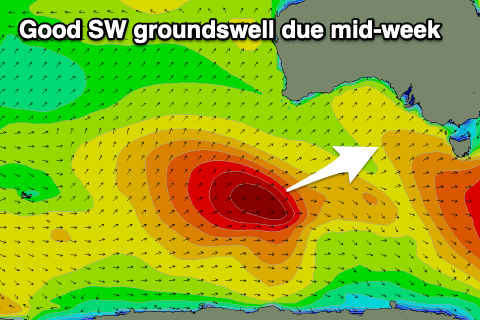
We then look to our new moderate + sized SW groundswell for Wednesday with, the polar low linked to it, now weakening under the country. Before it weakened, the low generated a great, slow moving fetch of severe-gale W/SW winds through our medium range swell window, and this should fill in Wednesday, peaking to 4-5ft+ across Middleton with 1ft to possibly 2ft sets on the Mid Coast with the favourable parts of the tide.
Winds will favour the gulf with a light E/SE-SE offshore, workable down South for the keen with similar light winds, giving into S/SE-SE sea breezes.
Unfortunately Thursday, as the swell eases, winds will strengthen from the SE-S/SE (tiny on the Mid Coast), with gusty E/SE winds Friday morning.
So with this outlook it's worth getting in today and if local, early tomorrow and Wednesday for a paddle down South.
The surf will continue to become smaller through the weekend but with improving conditions with a light E/SE-SE breeze Saturday morning cleaner Sunday with an E/NE-NE offshore but with smaller, 1-2ft sets.
Longer term, early next week looks to remain slow before the Southern Ocean storm track starts to fire up for the middle to end of the week. More on this Wednesday.