Good swell tomorrow spoilt by onshore winds, cleaner Friday

South Australian Forecast by Craig Brokensha (issued Wednesday 28th June)
Best Days: Friday South Coast, Saturday South Coast, stormy options Monday
Recap
A touch more size than expected across the Mid Coast yesterday with 1-1.5ft sets through the morning, a touch smaller into the afternoon.
The South Coast offered solid clean waves all day, dropping back a bit today but still nice and clean with a morning offshore wind ahead of a shallow westerly change which moved in around midday.
This week and weekend (Jun 29 – Jul 2)
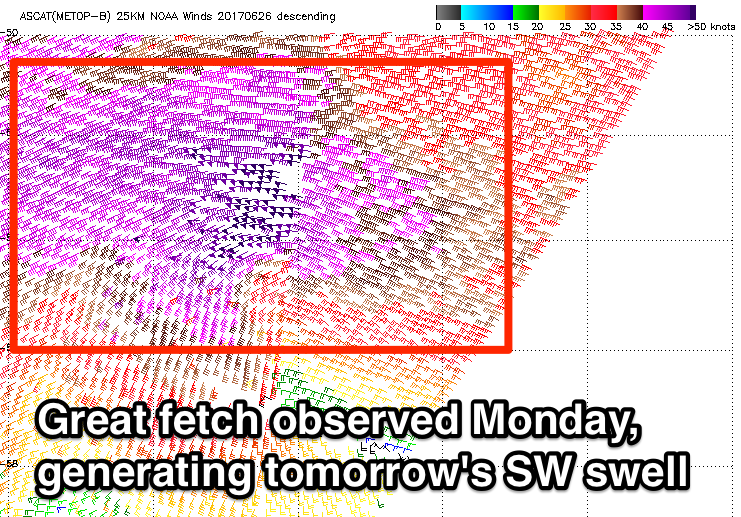
Satellite observations look great regarding the storm responsible for tomorrow's new long-period SW groundswell. A fetch of severe-gale W/SW winds were generated south of WA on Monday with core wind speeds hitting the 50kt range.
 A good inconsistent SW groundswell is due to arrive just after dark today, peaking tomorrow morning to a solid 4-5ft across Middleton, larger at more exposed breaks.
The Mid Coast should hang around the 1ft range but winds are now looking poor across all locations with a surface trough moving in from the west expected to bring a S/SW change to the South Coast on dawn, swinging more SW into the afternoon but persisting.
This trough will be related to a polar front projecting up towards us through our southern swell window from a similar position to Monday's front. This system will be much weaker though, projecting strong S/SW winds towards Victoria.
This should produce a reinforcing mid-period S/SW swell for Friday coming in around 3-5ft across Middleton, easing back from the 3ft range Saturday morning.
The Mid Coast will remain tiny with 0.5-1ft sets for beginners. Conditions are looking better Friday with an approaching front swinging winds locally offshore across both coasts, becoming variable into the afternoon.
Fresher N/NE winds will create excellent conditions Saturday morning, easing off into the afternoon.
Now moving into Sunday a small SW groundswell is due across the South Coast produced by a pre-frontal fetch of strong NW winds moving through our swell window tomorrow.
This won't be ideal for the Mid Coast, but a stronger polar frontal progression behind this pre-frontal front will generate a larger swell discussed below.
Back to the South Coast and Middleton should hold at a small 2ft Sunday with strong and less than ideal N'ly winds.
These N'ly winds will likely kick up some windswell on the Mid Coast to 1-1.5ft through the afternoon.
 Now, coming back to the stronger polar frontal progression, and we'll see this storm develop east of Heard Island this evening, projecting a slow moving fetch of gale to severe-gale SW winds up towards WA and the Bight over the coming days, generating a moderate to large W/SW groundswell that may be seen later Sunday but will peak Monday to 2-3ft on the Mid Coast and 4-5ft across Middleton.
The strong frontal progression will turn into a broad low through Sunday and Monday, pushing east and re-strengthening right on our doorstep Monday morning. This will see a fetch of gale-force W/SW winds slammed into us, kicking up a larger storm-swell on the Mid Coast to the 4ft range, while being a little too west for the South Coast.
These gales will create average conditions down South, with slightly better winds Tuesday.
We'll have a closer look at this Friday though.
Comments
Nice lines at Middleton this afternoon.