Great waves Saturday, good again down South Monday

South Australian Forecast by Craig Brokensha (issued Friday 9th December)
Best Days: Both coasts tomorrow morning, Mid Coast Sunday, South Coast Monday morning, swell magnets Tuesday morning down South
Recap
Stormy waves across the Mid Coast yesterday to 2-3ft with strong onshore winds, while the South Coast was bumpy and not that big, kicking larger through the afternoon as winds tended more onshore.
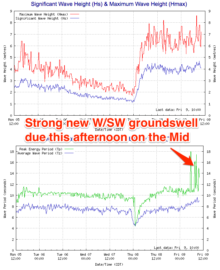 Today a lighter S'ly wind has created much cleaner conditions on the Mid with 2ft of swell, and a strong new W/SW groundswell has hit the Cape du Couedic wave buoy, and we'll see 3ft surf develop this afternoon.
The South Coast was poor and sloppy with a junky 3ft of swell.
This weekend (Dec 8 - 11)
This afternoon's strong pulse of W/SW groundswell should reach an easy 3ft on the Mid and 3-4ft at Middleton down South, before easing off through tomorrow and further Sunday.
The Mid should still see 2ft sets tomorrow morning, with easing 3ft waves off Middleton.
Conditions will be great on the Mid with a straight offshore, while the South Coast will be best mid-late morning with a NE'ly before sea breezes kick in.
Sunday should be smaller again, with tiny fading waves on the Mid around 1ft+ with a fresh E/SE offshore wind. The South Coast should see E'ly winds but not the greatest conditions.
Next week onwards (Dec 12 onwards)
Monday's new pulse of SW swell has been downgraded just a touch but conditions are still looking great.
The pre-frontal and post-frontal fetch of winds generating the swell are forecast to be a touch weaker and with this we'll see a touch less size. Middleton is expected to come in around 2ft+, with 3ft+ waves at Waits and Parsons.
The Mid should see tiny 1ft waves persisting.
A N/NE tending N/NW wind is due down South ahead of weak afternoon sea breezes, while the Mid should see an E/NE tending variable wind.
A fresher offshore breeze is due Tuesday but the swell will be smaller and only to 1-2ft at Middleton.
Into the end of the week and following weekend, a couple of moderate sized S/SW groundswells are due, produced by back to back polar lows firing up under the country.
Winds with these swells don't look ideal with a a strong high stalling over the Bight directing S/SE breezes across the state. More on this Monday. Have a great weekend!
Comments
Surfcam randomly captured some bloke flying down the line at the Hump this morning.
Some earlier grabs: