Fun waves Tuesday/Wednesday ahead of tricky severe low

South Australian Forecast by Craig Brokensha (issued Monday 26th September)
Best Days: South Coast Tuesday and Wednesday morning, Mid Coast Wednesday afternoon, both coasts Saturday
Recap
Small waves at swell magnets for keen surfers on Saturday morning, but Sunday was much better with a new swell and light morning offshore. The Mid Coast was tiny and choppy Saturday with a bit more size Sunday although with a straighter onshore.
Today was the pick with great conditions on the South Coast and good sized waves off Middleton/Goolwa and better surf at Waits. Winds have shifted more W'ly now though creating average conditions.
This week and weekend (Sep 27 - 30)
A fun mix of swells are due tomorrow, the first being a short-range W/SW swell from a weak fetch of W/SW winds moving into us this afternoon. This will provide 1-2ft waves on the Mid Coast and small 2ft+ waves at Middleton down South.
A better SW groundswell is due to fill in through the morning though down South, building to 3ft at Middleton.
Conditions should be good in semi-protected spots all day down South with a W/NW breeze, likely tending NW into the evening.
The swell should drop into Wednesday morning, but through the afternoon a new W/SW groundswell is due, generated by a strong storm projecting up towards WA and then through the Bight yesterday and today.
A fetch of gale to severe-gale W/SW winds have been generated in our western swell window, with the swell due to kick to a strong 2ft+ on the Mid Coast into the afternoon and 3ft+ at Middleton.
Winds will be funky and tricky as a deepening low pressure system to our west directs strengthening N/NE tending E/NE winds across the coast, swinging from a strong N/NW Thursday morning, to the S'th through the day.
 Now, this low pressure system will be quite significant and destructive. It's not quite going to reach the 'bombing low' status with it just falling short of the criteria of dropping 24hPa in central pressure in 24 hours, but it will still be a beast.
This low will start to develop Wednesday afternoon as it drifts in from the west in the form of a deepening surface trough.
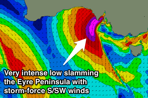
Into Wednesday evening we'll see a tight deep low pressure cell form, resulting in a fetch of storm-force S/SW winds to be slammed into the Eyre Peninsula, moving east towards Adelaide Thursday while weakening.
This is quite a tricky swell to forecast due to the focussed and localised nature of the fetch into the West Coast from the S/SW with a small W/SW wrap.
The swell from this low should build rapidly Thursday across the Mid Coast with a mix of W/SW groundswell and then SW windswell for Friday.
The models are still moving a touch regarding the position of this low so check back Wednesday for a clearer idea on the swell and winds, but we should see the Mid Coast building to a solid 3ft+ through the day Thursday with strong NW tending SW winds, with 3ft of windswell for Friday.
The South Coast isn't likely to see any size at all until very late Thursday due to the fetch around the low not being within its swell window.
Come Friday though once the low pushes further east, a fetch of severe-gale S/SW winds will be aimed directly into the South Coast generating large stormy waves to 8ft or so.
The low will quickly weaken through Friday afternoon and evening, with winds swinging back to the N'th with rapidly easing S'ly swell from 4-6ft across most most beaches Saturday. With the offshore wind and swell combo there'll be quite a few options to suss out. The Mid Coast will be fading quickly from 1-2ft or so and cleaning up.
Longer term a new W/SW groundswell is on the cards for Monday, but we'll have another look at this on Wednesday.
Comments
The latest hi-res BOM 3 Day model has 50-55kt winds aimed more into the Mid Coast's swell window now.
If this comes off we'll be looking at easy 4-5ft storm surf Thursday arvo.
We'll keep a close eye on this.
8.5m @47kts..here we go