Fun waves most days across both South Oz coasts; solid swell next Wed/Thurs

South Australia Surf Forecast by Ben Matson (issued Friday 27th May)
Best Days: Sat: small OK waves on the Mid Coast. Sun: clean and offshore at Victor. Mon/Tues: small and clean at Victor. Wed/Thurs: new groundswell building with small fun waves on the Mid Coast, bigger at Victor, likely clean both coasts.
Recap: Plenty of surf on the Mid Coast over the last few days, with Thursday’s conditions offering reasonable opportunities thanks to an onshore airstream generally under 10kts all day. Bigger surf has developed today though quality is very low, with gale force NW tending SW winds whipping up an impressive stormy. Conditions have remained much cleaner at Victor Harbor with a building swell across the region.
This weekend (Saturday 28th - Sunday 29th)
No major changes to the weekend.
The Mid Coast will see easing swell both days. Today’s onshores are expected to persist into the evening but then abate rapidly during through Saturday morning, tending S'ly then S/SE. So there’s a chance for some early morning surface bump and wobble but the trend will be improving all day despite the abating size.
Early morning should see 2ft, maybe 2-3ft sets, easing to 1-2ft throughout the day so keep a lid on your expectations as there won't be a lot of strength in the swell.
Sunday looks clean in the morning with early NE winds but they’ll swing N’ly during the day. Surf size is expected to level out between 1-2ft and become very inconsistent and tidally dependent, so there should be waves about the coast from time to time but you'll need to be patient. Aim for an early surf if you’re desperate.
At Victor, Saturday morning’s likely to be suffering poorly from the effects of a strong S'ly airstream developing in the wake of today’s change. Normally, winds tend SW behind a front but we have a small embedded low pressure system developing west of Mount Gambier that’s expected to track NE, and in doing so will drag cold, gusty southerly winds behind it.
That being said, the low will clear quickly to the east, the pressure gradient will relax quickly and local winds should abate to under 10kts by mid-afternoon. So, we’ll see a steady improvement as the day wears on but it’ll be starting from a pretty low base.
Victor’s surf on Saturday will consist of leftover groundswell from today (which seems to be pushing around the 3-4ft+ mark at Middleton) plus some choppy local windswell in the mix. Expect smaller surf on the balance into the afternoon, as today’s groundswell will be easing and the windswell won’t last very long.
Sunday looks like a great day for the South Coast with winds veering to the NE and freshening - this will iron out any residual lumpiness from Saturday’s early onshores. We should see inconsistent 2-3ft sets at Middleton, and bigger, better waves at Waits and Parsons.
Next week (Monday 30th onwards)
A large high pressure system will migrate slowly across the eastern states early next week, anchoring itself in the southern Tasman Sea as a blocking pattern and directing N'ly winds across the region from Monday thru’ Thursday at least.
So, this means we’ve got a whole week of great conditions for the South Coast.
This blocking pattern will also keep the Southern Ocean storm track away from our region, which means surf quality should be quite good, though set waves will be very inconsistent.
A conveyor belt of storms way our near Heard Island right now is generating some long period W’ly swell that’s due to arrive in several stages throughout Monday and Tuesday. At this stage no great size is likely due to the large travel distance - and the westerly direction probably won’t favour Victor very well. We should see small waves building across the Mid Coast (1-2ft sets) though the models are expecting moderate to fresh N’ly winds, which could create some problems. That being said, there’s a reasonable chance for a period of NE winds and it’ll be worth keeping an eye on the surfcam during the afternoon tides.
Expect small clean surf at Victor best suited to Waits, Parsons and Goolwa.
A much more significant development of this same storm pattern is then expected to take place east of Heard Island around Monday, and this is expected to generate a big, more defined groundswell arriving sometime Wednesday morning, building through the afternoon before peaking overnight, holding through Thursday morning and then easing into the rest of the week.
This low looks quite incredible on paper, and the swell quality from it is expected to be very high - the leading edge swell periods should top 18-29 seconds, and we should see great waves right across the state.
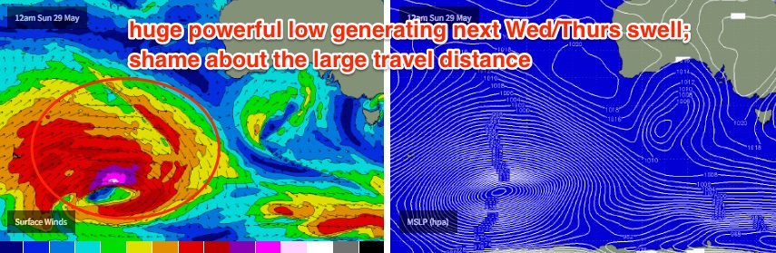
So, Wednesday looks good at this stage with the surface high expected to weaken, allowing lighter N/NE winds to develop across the region. Set waves from this swell will be very inconsistent but the incoming tide should produce inconsistent 2ft, maybe 2-3ft sets on the Mid Coast late on Wednesday afternoon, and up to 4-5ft at Middleton (bigger at Goolwa and Waits) by late in the day. This size range is likely through Thursday too, though I’m not quite as confident on the Mid Coast performing from this swell due to the large travel distance.
Thursday’s swell will then ease through Friday, and at this stage current expectations are for favourable winds.
Looking into next weekend, and follow up fronts behind Monday’s impressive low should maintain plenty of moderate westerly swell through Saturday and Sunday. Craig will have more on that in Monday’s updated notes.
Until then have a great weekend!
Comments
Craig was at Middleton earlier today, and reckons there were occasional 3-4ft sets off the point breaking a long way out.
Looking at the surfcam now though, and there are lengthy breaks between sets. Still pretty clean though despite the damaging weather warning recently issued by the BOM.
First wave of the set...
Second wave of the set...
Wow.. 20-25kt S/SE winds at dawn across the South Coast, but it then eased rapidly over the following hours and was 5kts N/NE at 9am!
Still looks like a dog's breakfast in the surf zone but it's improving quickly. Could be some halfway decent options mid-late afternoon.
Lots of warm current moving across the bight with the low cell surge today