Indonesia/Maldives forecast October 24th

Indian Ocean Basin analysis by Craig Brokensha (issued Thursday 24th October)
This week through next week (Oct 20 – Nov 3)
The weekend's small pulse of mid-period S/SW swell came in on target, peaking through Sunday and then easing into yesterday, further today.

For the rest of the week there's nothing too significant on the cards, with an inconsistent background S/SW swell due to bump wave heights slightly Thursday afternoon, peaking overnight before easing Friday.
Into the weekend, some funky, weak mid-period S'ly swell is due into later Saturday but more so Sunday, generated by a fetch of strengthening S'ly winds off the WA coast, south of us later this week.
With no other swells in the water this looks to be the most visible ahead of some small, background mid-period swell next Monday/Tuesday.
Now, unfortunately the frontal progression linked to this swell has continued to downrgrade and it doesn't look significant at all with a weak burst of sub-gale-force winds only due to generate a small to moderate sized kick in swell.
Following this the outlook remains very slow and lack lustre.
All these swells will be smaller and weaker towards western Indonesia apart from the S'ly energy which looks to peak Monday in the moderate size range.
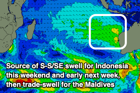
Over towards the Maldives, the current low point in SE trade-swell energy will end from tomorrow with strengthening trades throughout the Indian Ocean due to start up the swell generating system with building surf in size and power due from tomorrow afternoon but more so Thursday.
Background levels of S'ly swell will offer the most size across the southern atolls tomorrow, while the following trade-swell will muscle up into the end of the week and likely peak on the weekend in the moderate size range.
There's the possibility of some stronger trade-swell to come into later next week but we'll discuss this Thursday.
Eastern Indonesia:
Fading, small surf over the coming days.
Small, inconsistent mid-period S/SW swell building Thursday, reaching 3-4ft across exposed breaks, easing Friday.
Small mid-period S'ly swell for late Saturday, peaking Sunday to 3-4ft.
Small to moderate sized S/SW swell building Monday reaching 3-5ft across the magnets into the afternoon, easing Tuesday.
Weak E/SE-SE trades tomorrow and Thursday, light and variable each morning. Winds tending S'ly Friday and Saturday afternoon's, weaker S next week.
Uluwatu 16-day Forecast Graph/WAMs
Western Indonesia/Mentawais/South Sumatra:
Small most of this week, with a little kick in mid-period S/SW swell late Thursday and Friday to 3ft+.
Moderate sized S-S/SE swell building Sunday, peaking Monday to 4-5ft with a smaller, background mid-period S/SW swell in the mix.
Weak S/SE-SE trades across southern locations. Variable winds to the north. Winds strengthening later in the week (Thursday afternoon) and more into Friday from the S/SE-SE across southern locations, weaker to the north.
Strong S/SE-SE winds persisting on the weekend and early next week, slowly abating next week.
Mentawai 16-day Forecast Graph/WAMs
Maldives:
Small background levels of S'ly to 2ft+ across the southern atolls.
Building SE trade-swell from later tomorrow but more so Thursday, peaking on the weekend to 3-5ft across the southern atolls (smaller Male).
Slight drop in trade-swell into early next week with some stronger swell due later in the week.
Weak E/SE-SE winds across central and northern locations tomorrow, fresher to the south, persisting from the E into the end of the week and weekend.
Persistent mod-fresh E'ly winds across central and northern locations next week, fresher to the south.
Comments
Latest notes are live. Slim pickings.
Anyone got any current updates on inshore water temps around Bali please? Still needing some rubber?
No rubber needed
So water temps are warm then? BTW - I'm soft when it comes to water temps.
Fine Don, just a touch cooler around Bali.
Looks 26-28°C or so.
Thanks Craig but I find the accuracy of those charts for inshore water temps not great.
just got back last Friday and found the water a little cooler than normal
Thanks VB
Swell kicked here in Sumbawa late to 3 foot from 1-2. Surfline has it building tomorrow with a pulse Friday..
There was a little uptick in the SW of WA Monday, which explains this arvo a rise, but it’s been down hill ever since, Tiny today.. not sure where your Friday swell is coming from, but it’s not passing through the SW of WA..
Tiny down this way too @jamyardy.
8ft softy has had the cobwebs brushed off.
Yeah that's the minimal pulse due late week in Indo.
Uluwata forecast graph has it over 1.5m from Sunday until the following Friday, where Mentawai graph only has the Monday peak over 1.5m.
Is there likely to be a fair bit of difference in size between the Southern and Northern regions?
Yeah, the swell generators are further east so smaller for the Ments. The Ments will get more S/SE swell energy though :/
Bigger this morning. Just surfed wedge is which is solid and crew were getting barrels in middle. I'd say the 0.8m SSW at 15sec is massively over performing here. Looking at surfline cam Ulus looks pretty small.
Guess it's a swell magnet Yoyos but.
I will upload a photo if I can steal one from Santos.
SN been pretty bang on since I been here so interested if tomorrows swell kicks again.
Yeah that's the background swell due today, easing tomorrow.
Friday swell 2 foot. Half the size of Thursday.. So surfline uptick for Friday was not correct.
CangguWatu..
https://balibelly.com/pages/uluwatu
:o