Indonesia/Maldives forecast August 31st

Indian Ocean Basin analysis by Craig Brokensha (issued Thursday 31st August)
This week through next week (Sep 1 - 8)
Some small, inconsistent background S/SW swell is due to be filling in today across the Indonesian region, easing tomorrow, smaller into Saturday.
A further pulse of small to moderate sized, background S/SW energy is expected into Sunday and Monday but again with no significant size.
The Mentawais are seeing small to moderate levels of S'ly trade-swell this week spreading out radially from the expansive fetch feeding into the Maldives, with it due to linger into early next week, easing from Wednesday.
We then look towards our moderate-large, back to back S/SW groundswells for Tuesday afternoon through Thursday next week.
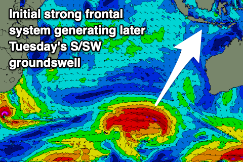
Back to back frontal systems will generate these swells, with the first now due to be the strongest and best swell producer.
The first system has formed west of Heard Island and is generating a great fetch of W'ly gales and will continue while tracking slowly east-northeast towards Western Australia this evening and tomorrow. It'll broaden while weakening on Saturday, with a strong, long-period S/SW groundswell due to push up towards the islands, building rapidly Tuesday, peaking into the evening and then easing Wednesday.
A secondary intensification on the backside of the first low, just off the South West of Western Australia should produce a reinforcing pulse of more S'ly swell Thursday, then easing Friday.
Into next weekend, a third, final and smaller but still good sized S/SW swell is likely, generated by a third, final frontal system moving up from the Heard Island region early next week.

These swells will impact the Maldives through most of next week, with the first being the largest, coming in around the moderate sized range, peaking Tuesday afternoon, easing Wednesday.
The current large, super-charged SE trade-swell is expected to ease over the coming days, reaching a low point Sunday evening before new levels of SE swell build again through next week.
This will be thanks to a breakdown in the SE trades through the Indian Ocean, strengthening again from Friday. They'll become quite robust on the weekend before weakening again slightly next week.
This should see a fun spike of moderate + sized SE trade-swell Monday/Tuesday, easing a touch through Wednesday and Thursday.
Eastern Indonesia:
Small-moderate sized S/SW swell peaking today/tomorrow to an inconsistent 4-5ft across exposed breaks.
Small to moderate sized, background S/SW swells for Sunday/Monday.
Large S/SW groundswell pulses for next week, with the first building Tuesday to 8ft across exposed breaks later, easing from 6ft to possibly 8ft Wednesday morning. Secondary reinforcing S/SW groundswell Thursday (7th) to 6ft+ across exposed breaks, easing Friday (8th). Smaller, third similar sized swell for later Saturday (9th), easing Sunday (10th).
Moderate E/SE-SE trades (fresh at times), light and variable each morning.
Uluwatu 16-day Forecast Graph/WAMs
Western Indonesia/Mentawais/South Sumatra:
Moderate sized mid-period S/SW swell for later today and tomorrow to 4-6ft.
Small levels of S/SE swell early next week.
Mod-large S/SW groundswell building Tuesday, reaching 6ft ti possibly 8ft across exposed breaks late, dropping from 6ft+ Wednesday morning.
Reinforcing pulse of S'ly groundswell later Thursday (7th) but more so Friday (8th) to 4-6ft across exposed breaks, with a final pulse of smaller S'ly swell Saturday (9th).
Persistent, fresh S/SE-SE trades across southern regions, lighter to the north, strengthening from the weekend and more so into next week (mod-fresh northern regions).
Mentawai 16-day Forecast Graph/WAMs
Maldives:
Large easing SE trade-swell from the 8ft range this morning across exposed breaks.
Drop in swell into Friday with a less consistent but strong S/SE swell for later in the day, peaking Saturday morning to 4-6ft across the southern atolls, smaller Male.
Slight drop in swell Sunday ahead of some new SE trade-swell for Monday/Tuesday to 5-6ft across the southern atolls (smaller Male).
Small, inconsistent background S'ly groundswell building Tuesday to 4ft across the southern atolls into the afternoon, easing slowly Wednesday.
Moderate to fresh W winds across central and northern locations tomorrow, lighter S to the south. Winds tending SW into the weekend, mod-fresh S-S/SE across southern locations.
Moderate S/SW-S winds across central and northern locations next week, S/SE-SE to the south.
Comments
Latest notes are live.
Will be around the Bukit from 7-15th. How do these forecast numbers usually translate into real world size at the big names from Uluwatu to Balangan? Trying to figure out what boards to take.
Sizes would line up to my expectations across Ulu's on the sets, though more so the Bombie etc and other magnets. Especially if the swell has south in it.
It looks like the 15-18th could have one of the biggest swells of the season. Long way out but right now that storm is looking super intense and it has quite a bit of west in the direction, like 210-215 degrees. I'm heading over for a few weeks from the 15th
GFS is much more bullish than EC, temper the expectations until the models converge.
Agreed. And also a long way out so models tend to be rather bullish as they project further into the future. Particularly GFS.
I’m also heading over with first day in the water Sat 16th.
Maldives or Indo?
Indo but looking at the forecasts I have asked the boat captain if he’d like to take a slight detour to the Maldives!!
Ok this shit ain’t funny anymore with EC also now starting to get on board!!
ECMWF?
Yes
Good that's what I use and agree on GFS, ICON even more bullish IMO for Indian Ocean Basin
Have a great trip Don, hope you score
Thanks SS. I hope we score too....just not wanting one of the biggest swells of the year to coincide with our first few days of the trip!!!
That secondary system EC is bullish on is insane!!!
Indeed, I've been monitoring that since back end Aug and taken a few screen shots over various days to compare.
metabo oyagi book your Flight Yew!
I just ran the numbers on that EC fetch above Heard Island around this time next week. If that forecast comes to fruition, holy fck me I'm gonna be in some serious trouble over the first two day of my trip!!!!
Calm the farm, it's just looking like the last few large swells at this stage. Maybe peaking 10ft max but mostly 8ft range. Lots to play out and unfold with multiple embedded fronts.