Indonesia/Maldives forecast August 29th

Indian Ocean Basin analysis by Craig Brokensha (issued Tuesday 29th August)
This week through next week (Aug 30 – Sep 8)
Generally small surf dominates the Indonesian region with a small pulse of inconsistent S/SW swell energy through later tomorrow but more so Thursday/Friday downgraded a little from Thursday's forecast.
Further pulses of small to moderate sized, background S/SW energy are expected into Sunday and Monday but all in all with no major size.
The Mentawais will see small to moderate levels of S'ly trade-swell this week spreading out radially from the expansive fetch feeding into the Maldives, detailed further below.
Looking at Tuesday through Friday next week though, and a more noticeable increase in swell is due across Indonesia, generated by a strong polar frontal progression projecting up and into Western Australia later this week and weekend.
An initial frontal system will produce a slow moving fetch of W/SW gales, weakening on approach to Western Australia ahead of a secondary system firing up on its tail, generating an additional burst of SW gales.
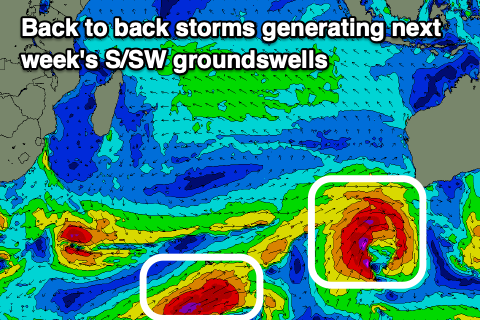
This should produce a prolonged, large S/SW groundswell event with the first pulse building Tuesday and peaking later, with a secondary reinforcing pulse for Thursday. There might be a third trailing storm and third pulse of large S/SW groundswell for next Saturday but we'll review this on Thursday.
For the Maldives we've got our super-charged SE trade-swell on the build with the larger stuff due to arrive through this afternoon, holding tomorrow and then slowly ease from Thursday ahead of a more distant, reinforcing S/SE pulse arrives later Friday and more so Saturday.
The source is an expansive fetch of strong E/SE-SE trades across the Indian Ocean, with a small trough producing a little dip and squeeze off Western Australia today.
The trades will weaken from today resulting in a temporary easing trend before we see a new high pressure system fill in later week, bringing a renewal of moderate to large sized SE trade-swell into early-mid next week.
The S'ly groundswell impacting Indonesia will spread out in small, inconsistent pulses for next week, though below the more localised SE swell.
Eastern Indonesia:
Small-moderate sized mid-period S/SW swell easing from 3-5ft across exposed breaks today, smaller tomorrow.
Small-moderate sized S/SW swell building later Wednesday, peaking Thursday/Friday to an inconsistent 4-5ft across exposed breaks.
Moderate sized, background S/SW swells for Sunday/Monday to 4-6ft (peaking Monday).
Large S/SW groundswell pulses for next week, with the first building Tuesday to 6-8ft across exposed breaks, easing to 6ft+ Wednesday. Secondary reinforcing S/SW groundswell Thursday (7th) to 6-8ft across exposed breaks, easing Friday (8th). Possible third similar sized swell for Saturday (9th).
Moderate to fresh E/SE-SE trades, light and variable each morning.
Uluwatu 16-day Forecast Graph/WAMs
Western Indonesia/Mentawais/South Sumatra:
Moderate sized mid-period S'ly swell peaking this morning to 4-5ft, easing slowly over the coming days.
Moderate sized, S/SW swell building later Wednesday, peaking Thursday to 4ft+.
Moderate sized mid-period S/SW swell for later Thursday and Friday to 4-6ft.
Small levels of S/SE swell next week.
Mod-large S/SW groundswell building later Tuesday, reaching 6ft+ across exposed breaks, dropping from 6ft Wednesday morning. Reinforcing pulse of S'ly groundswell later Thursday (7th) but more so Friday (8th) to 6ft+ across exposed breaks, with a final pulse of possibly larger swell next Saturday (9th).
Persistent, fresh S/SE-SE trades across southern regions, lighter to the north, strengthening from the weekend and more so into next week (mod-fresh northern regions).
Mentawai 16-day Forecast Graph/WAMs
Maldives:

Large SE trade-swell building into this afternoon and holding through Thursday morning to 8ft across the southern atolls, 6-8ft Male.
Drop in swell into Friday with a less consistent but strong S/SE swell for later in the day, peaking Saturday morning to 4-6ft across the southern atolls, smaller Male.
Slight drop in swell Sunday/Monday ahead of some new SE trade-swell through Tuesday/Wednesday to 5-6ft across the southern atolls (smaller Male).
Small, inconsistent background S'ly groundswell most of next week.
Moderate to fresh W-W/NW winds across central and northern locations, lighter S to the south. Winds tending SW from Friday into the weekend, fresh S/SE across southern locations, light again into next week.
Comments
Latest notes are live.
Thanks Craig.
Can you or any other Swellnettians advise on the timing of swell arrival for eastern Indo (NTB, NTT)?
I'm presuming the forecast for Eastern Indonesia is primarily referring to Bali/Lombok - how much longer does it usually take for that swell to arrive at islands east from there?
Sorry I missed this, yeah probably 6 hour approx delay from Bali. Depends on direction and period. The more south, the less difference in timing, but also the smaller it'll be to the east. The more west, the timing will be longer.
Maldives off tap!!
Finally models are hinting at a slight breakdown of the large and relentless blocking highs in their long range charts. Albeit mainly GFS with a more rosier forecast outlook for Indo.