Indonesia/Maldives forecast August 24th

Indian Ocean Basin analysis by Craig Brokensha (issued Thursday 24th August)
This week through next week (Aug 25 – Sep 1)
We saw a large S/SW groundswell building across the Indonesian archipelago yesterday afternoon, peaking overnight and now slowly on the ease. This easing pattern will continue further into the weekend as the Southern Ocean goes quiet.
A slight slowing of this trend is expected across eastern Indonesia on Saturday as a small, reinforcing mid-period S/SW swell fills in, though it isn't expected to offer an additional size.
Across the Maldives the S'ly groundswell peaked over the last two days with it now easing.

A small to moderate sized mid-period S/SW swell is due off a low forming west of Western Australia today, building into Monday afternoon, then easing Tuesday. No major size is expected from this low, but the Mentawais will see the most energy.
Our small to moderate sized, inconsistent S/SW groundswell for later week is on track, generated by a polar fetch of gale to severe-gale W/NW winds on the polar shelf, forming late in Indonesia's swell window.
It'll be inconsistent but should provide a late kick in size Wednesday, peaking Thursday morning and then easing (smaller across the Mentawais).
Other than that, the next large pulse of groundswell looks to build through the first week of September, generated by a strong Southern Ocean frontal progression firing up to the south-west of Western Australia. We'll have a closer look at this next Tuesday.
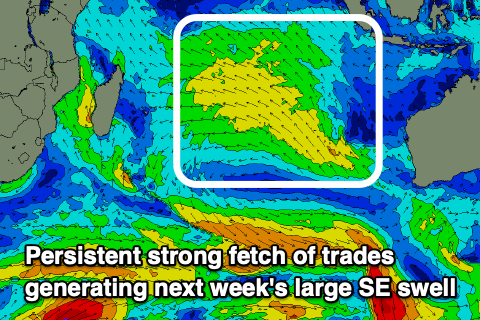
We then look at the super-charged SE trade-swell due across the Maldives next week, with the Mentawais also receiving moderate levels of mid-period S'ly swell from the same source.
Following an easing trend and low point through the weekend, an expansive, strengthening fetch of E/SE-SE trades are forecast to develop through the Indian Ocean from tomorrow, reaching maximum strength and scope early next week.
With the persistent, strengthening fetch acting on top of the same area of ocean we'll see rapid open ocean wave growth and a large, consistent SE trade-swell fill in rapidly early next week across the Maldives, becoming large from later Tuesday and holding through the rest of the week, only starting to ease from Friday.
The Mentawais will see small to moderate levels of side-band S'ly energy spreading out from the fetch which will create funky surf at times, with a larger pulse for later week from a trough squeezing the backside of the trade-fetch, off Western Australia early next week.
Eastern Indonesia:
Large, slowly easing S/SW groundswell today, further into tomorrow and the weekend.
Small-moderate sized mid-period S/SW swell building Monday afternoon, reaching 3-5ft across the magnets, easing from a similar size Tuesday morning.
Small-moderate sized + S/SW groundswell building later Wednesday, peaking Thursday to 4-6ft across exposed breaks, easing slowly Friday.
Larger SW groundswell on the cards for the first week of spring.
Moderate to fresh E/SE-SE trades today and tomorrow, light and variable each morning. Weaker winds all round from the weekend into most of next week.
Uluwatu 16-day Forecast Graph/WAMs
Western Indonesia/Mentawais/South Sumatra:
Easing S/SW groundswell slowly today, further tomorrow and into the weekend.
Moderate sized mid-period S'ly swell building later Monday, peaking Tuesday morning to 4-5ft.
Moderate sized, S'ly groundswell building later Wednesday, peaking Thursday to 4ft+.
Small to moderate sized mid-period S'ly swell also in the early-mid next week, with a mod-large pulse of S'ly swell for Thursday afternoon to 6ft+, easing Friday.
Persistent, strong S/SE-SE trades across southern regions, lighter to the north and more variable.
Mentawai 16-day Forecast Graph/WAMs
Maldives:
Slowly easing SE trade-swell this week, bottoming out on the weekend.
SE trade-swell building rapidly Monday afternoon, larger into Tuesday afternoon and holding through Thursday to 8ft across the southern atolls, 6-8ft Male.
Fresh W-W/SW winds today across central and northern locations, weakening tomorrow with S'ly winds to the south.
Light W winds on the weekend and next week through central and northern locations, variable to the south but tending S through early next week, variable after.
Comments
Notes are live.
Thinking of heading playgrounds (eBay, pitstops ect.) area or HT’s (lances left, lances right) mid September and wondering if any suggestions? Thinking HT’s better crowds more swell but playgrounds protected from late season SE trades
Metabo Oyagi
when is your Passport going to be Stamped with an Indonesian Entry....
:-]
august 28. Will be back September 24 so shouldn’t have visa overstay issues thankfully