Indonesia/Maldives forecast August 22nd

Indian Ocean Basin analysis by Craig Brokensha (issued Tuesday 22nd August)
This week through next week (Aug 23 – Sep 1)
Small surf is being seen today, though there's a chance for some new swell to show later in the day out of the S/SW, ahead of our larger S/SW groundswell through tomorrow.
Now, as touched on in Thursday's update, the Southern Ocean frontal progression linked to this swell was downgraded a little in strength and scope resulting in a downgrade in the expected size across Indonesia over the coming days.
We saw a great, broad fetch of W/SW gales moving slowly between Heard Island and Western Australia, generating a healthy S/SW groundswell that should build into tomorrow afternoon and peak through the evening, easing slowly Thursday.
The morning will be much smaller so don't expect any major size and also expect less energy to the west, across south Sumatra and the Mentawais.

Besides a small reinforcing mid-period S'ly swell for the Bali region on Saturday, the general trend in size will be down from Thursday morning, bottoming out into Sunday and early next week.
The next noticeable increase in swell will be through later next week, though only moderate + in size. The source will be a late forming polar frontal system generating W/NW severe-gales to the south-west of Western Australia late this week.
It'll be late in Indonesia's swell window and looks to favour eastern locations over western.
So all in all it looks to be a slow start to spring. Longer term there's nothing too significant showing up just yet but this is sure to change.
Looking at the Maldives and we've got an easing SE trade-swell signal as the S'ly groundswell from the Southern Ocean frontal progression fills in, peaking this afternoon ahead of a slow easing trend tomorrow.
Weakening trades throughout the Indian Ocean will see the trade-swell continuing to ease into the end of the week and weekend, only starting to build again through next week.
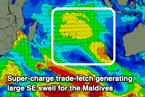
This building trend will be quite rapid and pronounced as the trades rapidly strengthen this weekend close to the atolls, sending in a large SE swell event for later Monday but more so Tuesday onwards that looks to easily reach 6-8ft.
This will be a rare moment where the Maldives will outperform their Indonesian counterparts. There's also due to be some S/SE groundswell from a small low forming in the central Indian Ocean over the coming days, though below what's seen from the super-charged fetch.
Eastern Indonesia:
Large, S/SW groundswell building tomorrow afternoon, reaching 8ft across exposed breaks late, easing from a similar size Thursday morning, slowly into the end of the week and weekend.
Moderate sized + S/SW groundswell building next Thursday (31st), reaching 6ft across exposed breaks, easing from a similar size Friday (1st).
Moderate to fresh E/SE-SE trades, light and variable each morning. Weaker winds all round from the weekend into early next week.
Uluwatu 16-day Forecast Graph/WAMs
Western Indonesia/Mentawais/South Sumatra:
Large S/SW groundswell building to 6ft+ across exposed breaks through the afternoon tomorrow, easing slowly Thursday and further into next weekend.
Strong S/SE-SE trades, lighter to the north, becoming more variable through the late week while still being fresh to the south, strengthening again next week.
Moderate sized, S'ly groundswell building Thursday (31st), reaching 5ft, easing Friday.
Moderate sized mid-period S'ly swell also in the mix mid-late next week.
Mentawai 16-day Forecast Graph/WAMs
Maldives:
Slowly easing SE trade-swell this week.
New, moderate sized S'ly groundswell building to 4-6ft across the southern atolls today, (smaller Male), easing slowly Wednesday.
Large SE trade-swell building rapidly later Monday (28th), peaking Tuesday through Thursday to 8ft across the southern atolls, 6-8ft Male.
Strengthening W/NW-W winds over the coming days, tending SW to the south. Weakening W winds Friday, S to the south.
Light W-W/NW winds on the weekend and next week, variable to the south but tending SE to E at times.
Comments
Latest update is live, and the Maldives are looking juicy.
Ooooft, Good call Craig - 7 days of very solid SE trade swell in Maldives from next Tuesday. This will possibly exceed the swell from 6 -10 August - check what that looked like https://www.perfectwavetravel.com/magazine/report/swell-of-the-season-ma...
Yep, it's looking chunky as! Def bigger than the last one at this stage.
Maldives is set to pump!!! It loves large blocking highs parked in the Indian Ocean
Positive IOD is declared and strongest its been in years, Maldives gets weeks of large SE swell - what is the relationship?
Nah, it's a weak and even neutral signal for now, 2019 was the last strong + IOD event and it was the strongest on record.
They do correlate though, re + IOD and super-charged SE trade-swells.
That would also imply a correlation with strong SE winds in the ments too?
Yep and mid-period S-SSE swells.
Fck that shit off!!
+ IOD not declared yet - but we are well on the way https://www.abc.net.au/news/2023-08-22/positive-indian-ocean-dipole-to-c...