Indonesia/Maldives forecast August 17th

Indian Ocean Basin analysis by Craig Brokensha (issued Thursday 17th August)
This week through next week (Aug 18 - 25)
We should be seeing our large mix of SW groundswell and S/SW swell filling in strongly today, reaching a peak this afternoon before tailing off slowly tomorrow but more noticeably through Saturday.
Our reinforcing pulse of S/SW groundswell for mostly eastern Indonesia is on track for Sunday morning, generated by a strong, small low firing up towards Western Australia the last couple of days. This will just slowing the easing trend a little more than normally seen with the surf becoming smaller Monday and bottoming out Tuesday.
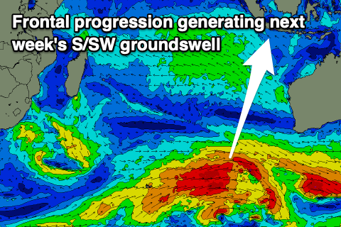
Looking at next week's S/SW groundswell and the models have gone the way of EC, as they mostly do, with a strong though late forming Southern Ocean frontal progression due to develop just west of the Heard Island region this afternoon.
Winds now only just look to reach the gale-force range as it pushes east and this has resulted in a downgrade in the expected peak in size of the S/SW groundswell, with it building Wednesday and reaching 8ft across exposed breaks into the afternoon in eastern Indonesia (smaller to the west), easing slowly from a similar size Thursday morning.
Following this the Indian Ocean goes quiet and there's nothing too significant at all to work with into the end of the month. We'll confirm this in the next update.

The Maldives are looking at easing S'ly groundswell from earlier in the week but the SE trade-swell looks to muscle up thanks to a broad, strong fetch of E/SE winds through the Indian Ocean, weakening a little over the coming days and remaining so-so through most of next week.
This will see moderate sized + levels of SE trade-swell building tomorrow, peaking through the weekend, easing slowly through next week. It'll also add some mixed, less than ideal S/SE energy to western Indonesia from today through tomorrow, easing slowly from Sunday.
The frontal progression developing across the Heard Island region will generate a moderate sized + S'ly groundswell that should build Tuesday, peaking into the afternoon, easing Wednesday.
Eastern Indonesia:
Large, inconsistent mix of SW groundswell and S/SW swell filling in today, peaking through the afternoon to 8ft to occasionally 10ft across exposed breaks, easing slowly into tomorrow and more noticeably Saturday.
Moderate sized + reinforcing S/SW groundswell for Sunday morning to 6ft across exposed breaks, easing through the day.
Large, S/SW groundswell building Wednesday, peaking through the afternoon to 8ft across exposed breaks, easing slowly into the end of the week and next weekend.
Moderate to fresh E/SE-SE trades (a little stronger early next week), light and variable each morning.
Uluwatu 16-day Forecast Graph/WAMs
Western Indonesia/Mentawais/South Sumatra:
Large, inconsistent S/SW groundswell peaking today to 8ft+ across exposed breaks, easing through tomorrow and further through the weekend. Moderate sized S/SE trade-swell in the mix across the south magnets tomorrow, easing from Sunday into next week.
Large S/SW groundswell for next Wednesday, building to 6ft+ across exposed breaks through the afternoon, easing slowly Thursday and further into next weekend.
Stronger S/SE-SE trades today and tomorrow, more variable to the north.
Slight weakening of S/SE-SE winds into the weekend though still fresh and gusty to the south, variable to the north. Strengthening S/SE winds again into next week.
Mentawai 16-day Forecast Graph/WAMs
Maldives:
Easing S'ly groundswell today and tomorrow.
Moderate sized + SE trade-swell on the build today and tomorrow, strongest Saturday/Sunday. Sets peaking to 6ft (slightly smaller Male). Slowly easing SE trade-swell through all of next week.
New, moderate sized + S'ly groundswell for Tuesday, building to 4-6ft across the southern atolls during the day (smaller Male), easing slowly Wednesday.
Persistent, moderate W/NW-W winds across northern and central locations, freshening from the weekend, easing from mid-next week. S across southern locations, variable early next week.
Comments
Latest notes are live.
Currently in java and feels like wet season, heaps of junk swell inbetween waves and swirling onshore with rain.
Will this weather clean up before the swell is over or here to stay?
Yeah you've got the S/SE trade-swell in the water which is expected to increase more over the coming days, easing slowly from the weekend (Sunday more so).