Indonesia/Maldives forecast July 4th

Indian Ocean Basin analysis by Craig Brokensha (issued Tuesday 4th July)
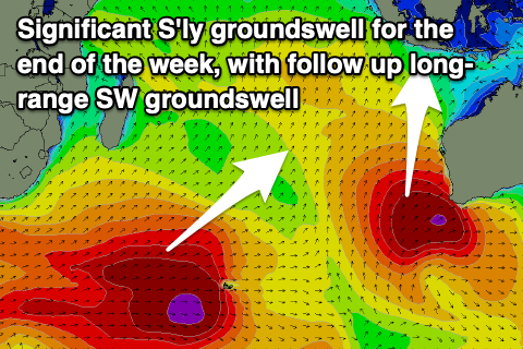
This week through next week (Jul 5 - 14)
Upgrade!

The frontal progression through the Indian Ocean seen late last week and through the weekend has come in stronger than forecast in its secondary stages and this will result in an upgrade in the final pulse of reinforcing S'ly groundswell for Friday.
Looking at the coming days and the initial stages, that being a great mid-latitude low and trailing frontal progression, should produce a building SW groundswell for tomorrow around Bali, becoming large into the afternoon as a secondary reinforcing pulse of large S/SW groundswell fills in from the trailing front.
The final stages of the progression saw a severe low form off the south-west of Western Australia yesterday, producing a fetch of slow moving, gale to severe-gale winds (embedded storm-force winds) which are providing XXL stormy surf to that state today.
The groundswell emanating off this low will come in more south and have the largest swell period and strength, kicking later Thursday ahead of a peak Friday morning.
Further west and across the South Sumatra/Mentawai region, an initial pulse of moderate to large S/SW groundswell is due this afternoon ahead of a secondary reinforcing pulse tomorrow afternoon/Thursday morning and then the large S'ly groundswell Friday.
The Maldives should be seeing the swell from the initial mid-latitude progression building today, with the secondary pulse providing the most size tomorrow (Wednesday).
The groundswell from the low off Western Australia is due to arrive out of the S/SE during Friday, peaking Saturday morning in the moderate size range.
At the same time there'll be a stronger, more consistent moderate sized + SE trade-swell in the water across the Maldives generated be a great fetch of broad, strong SE winds developing through the northern Indian Ocean. This doesn't look to get as strong as forecast last week but a consistent moderate sized SE swell is due from Friday through early next week, easing thereafter.
Coming back to the follow up, longer-range SW groundswell due from the developments to the south of South Africa, and this looks to have been downgraded a touch. The initial stage of the progression was great but in Indonesia's far swell window, with the follow up activity to the south and south-east of Madagascar being fairly week.
This will result in an inconsistent, moderate to large sized SW groundswell that's due to build Sunday across Indonesia and peak Monday (to the east).

The Maldives looks to come in as forecast though with the swell arriving later Friday and peaking Saturday, mixed in with the S/SE groundswell and SE trade-swell.
Longer term a healthy mid-latitude frontal progression forming in the southern and south-eastern Indian Ocean should generate some new, large S/SW groundswell for Indonesia late next week. More on this next update.
Eastern Indonesia:
Mod-large mix of SW and S/SW groundswells building later Tuesday but more so Wednesday with a groundswell peaking into the afternoon, holding Thursday morning. 6-8ft surf developing Wednesday afternoon, holding a similar size Thursday morning.
Large, long-period S'ly groundswell kicking later Thursday, peaking Friday with 10ft sets on the exposed breaks, easing into the afternoon and from 6-8ft Saturday. There's the chance for magnets to see some 12ft clean-ups at the peak of the swell so keep your eyes peeled.
Moderate to large, inconsistent SW groundswell building Sunday (9th), peaking Monday (10th) to 6ft to occasionally 8ft across exposed breaks.
Winds over the coming week look generally SE, strong through the aftenoons into the middle to end of the week, lighter tomorrow and with periods of variable winds each morning. Slightly weaker and more favourable E/SE trades look to kick in next week.
Uluwatu 16-day Forecast Graph/WAMs
Western Indonesia/Mentawais/South Sumatra:
Mod-large mix of groundswell and mid-period S/SW-S swell building Tuesday, peaking Wednesday/Thursday, reaching 6ft exposed breaks (possible bigger clean-up Thursday).
Larger, less consistent S'ly groundswell for late Thursday, peaking Friday to 8ft on the exposed south facing breaks (possible bigger clean-up southern locations), easing through the late afternoon and Saturday.
Larger inconsistent SW groundswell building later Saturday (8th), more so Sunday (9th) reaching 6-8ft across exposed breaks into the afternoon, easing from a 6ft to possibly 8ft Monday morning.
Winds look generally E/SE tending S/SE across western Indonesia, (fresh afternoons), with the pattern persisting through next week. To the north lighter, variable winds are due the whole period.
Mentawai 16-day Forecast Graph/WAMs
Maldives:
Moderate sized S'ly groundswell pulse building Tuesday across the southern atolls, reaching 4-5ft+, with a secondary larger pulse Wednesday to 5-6ft. Smaller across Male but still 4ft with a SE trade-swell.
Secondary pulse of S'ly groundswell building later Friday (7th), peaking Saturday, mixed in with a moderate sized, S/SE groundswell and moderate sized + SE trade-swell.
Surf in the 6ft range, easing Sunday as the SE trade-swell maintains 4-5ft+ surf (smaller Male), easing slowly early next week
Strong W/SW winds across the central and northern atolls tomorrow, weaker and S to the south, with weaker SW-S winds across central and northern locations into the end of the week, S-SE to the south Thursday, variable Friday.
Variable winds into the weekend, tending NW through early next week.
Comments
The latest from an action packed outlook.
Swell just showing on Bukit.
Nice, how big does it look?
Hard to say Head High maybe ?
https://balibelly.com/pages/uluwatu
Pumped!!!!
Thanks for the updates Craig. Just a question when looking at the 16 day forecast for East Java can I assume the modelling is based on G land?
No worries Nicko, Yep.
Busy up at Keramas this morning
Had to be some 8footers that landed on my head at Ulus today
but really 6ft plus and solid. Thanks for the updates Craig
Nice Evo!
Some Serious sets out Ulu this morning..
2 Surfers about to try it...on what look to be 6'0 ish Wafers
Saw a photo from east java yesterday. Very big.
monkeys gods are pleased no more silly contests planned at 'east java'