Smaller surf continues, with a larger swell on the long-term charts

Hawaii North Shore forecast by Craig Brokensha (issued Tuesday 22nd November)
Best Days: North Shore Wednesday, Friday, Saturday, Wednesday onwards next week, Micronesia late next week onwards
This week and next (Nov 22 – Dec 2)
Hawaii: A mix of N/NE and N/NW groundswells are breaking across the North Shore today in the 3-4ft range, with a drop in swell due through tomorrow from 3ft+ early.
A new moderate sized N/NW groundswell is expected Wednesday morning, produced the last couple of days by a strong but distant storm across the Aleutian Islands.
Good infrequent 5-6ft sets are due on the North Shore, easing through the day and further Thursday.
Friday's slightly stronger N/NW groundswell will be just that, only a touch stronger due to the storm generating it producing less favourably aligned but severe-gale to storm-force winds in our far swell window.
The swell is expected to build Friday and peak into the afternoon with inconsistent but strong 5-6ft sets, with the odd bigger cleanup. A slow drop is then expected from 4-6ft Saturday morning.
 Fresh to strong E-E/NE trades are due over the coming period, linked to a strong high pressure ridge sitting to our north, squeezed along the equator by a series of low pressure depressions.
This will produce moderate levels of E/NE trade-swell across exposed breaks to the east, sneaking into the North Shore every now and then.
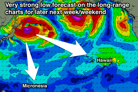
Longer term the next significant swell is due next Thursday, but only moderate to large in size from the N/NW, with a larger NW groundswell on the cards for Friday.
This has been forecast by the long range charts for a few days now, with a vigorous low expected to form off Japan and project towards us while producing a fetch of severe-gale W/NW winds.
More on this Thursday.
North Shore Forecast Graph
North Shore WAMs
Micronesia: The coming period will be made up of stock standard NE trade-swell across exposed coasts along with moderate fresh E/NE winds. Not the best combo.
The swell is expected to ebb and pulse with small intensifications and weakening of the overall trade-belt, easing a little over the coming days from 3-4ft+ before kicking again through the weekend before fading into next week.
Of greater importance is the low forming off Japan discussed above, with a moderate to large N/NW groundswell due to be generated for our northern shores Friday through the following weekend. We'll keep a close eye on this in the coming forecasts.
Palikir Pass Forecast Graph
Palikir Pass WAMs
Papua New Guinea: Similar to Micronesia, but smaller out of the NE over the coming period.
Size wise exposed breaks should see 2ft to occasionally 3ft waves with variable winds each morning and afternoon sea breezes.
The N'ly groundswell if it comes off would hit us in two weekends time, peaking Sunday, but more on this Thursday.