Dynamic period but generally weak swell producers

Eastern Tasmania Surf Forecast by Craig Brokensha (issued Monday December 18)
Best Days: Saturday morning
Features of the Forecast (tl;dr)
- Tiny N/NE windswell tomorrow AM, with a building S windswell into the PM
- Mod-fresh S/SW tending strong S/SE winds tomorrow
- SW tending S/SE-SE winds Wed
- Freshening SE winds Thu with a building E windswell
- E/SE winds Fri
- Peak in E swell Sat with SW tending E winds
- Fading surf Sun with W tending NE winds
- Moderate sized S/SE swell Mon with strong S/SE-SE winds
Recap
No real surf on the weekend with great conditions but no swell.
This week and weekend (Oct 19 - 24)
The small N/NE pulse identified last week as a source of energy for tomorrow looks to be minimal at best. Winds down the coast look weak and disjoined so don't expect much more than 1-2ft.
A trough bringing a S/SE change also looks much weaker with no swell of substance due in its wake Wednesday besides 2ft+ of S'ly windswell with onshore winds.
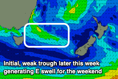
Of slightly greater significance is a trough deepening into a low in the Tasman Sea later this week.
This will see winds increase from the E/SE-SE later in the week as the trough slides south towards us, dipping further south while weakening on Saturday allowing light offshore SW winds to kick in.
This will coincide with a peak in weak E swell energy to 3ft or so across open beaches, easing into Sunday from 2-3ft.
Into early next week, we may see a secondary, stronger low forming to our east, bringing strong SE winds initially that will shift more S'ly into early next week along with moderate amounts of localised S/SE swell. It doesn't look overly well aimed but surf to 4ft is expected in northern corners, smaller towards souther ends which will be cleaner.
We'll take a closer look this dynamic period on Wednesday.