Good S swell for the weekend though winds are dicey

Eastern Tasmania Surf Forecast by Craig Brokensha (issued Friday 22nd January)
Best Days: Late Saturday, late Sunday, Monday morning south magnets
Features of the Forecast (tl;dr)
- Building S groundswell late tomorrow with NW winds on dark, strongest Sun but with S tending E then NE winds
- Easing S groundswell Mon with N/NW tending N/NE winds
- Possible large, stormy E swell late week
Recap
Great waves yesterday morning with clean, easing sets from 3-4ft, all but gone this morning.
This weekend and next week (Jan 23 - 29)
Tomorrow morning is likely to start out tiny, but into the late afternoon and more so Sunday, our strong S’ly groundswell from a slow moving polar low is due to fill in.
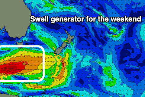 The low is currently south-west of us, with a drawn out and slow moving polar low currently generating a great fetch of gale to severe-gale W/SW winds. This is just within our swell window and not ideally aimed, with the secondary developments falling more favourably in our swell window (as it moves east).
The fetch strength will be maintained through our swell window today before shifting slightly more zonal but projecting east-northeast tomorrow, generating better energy Sunday/Monday.
Size wise, a late pulse to 2-3ft is due across the south magnets tomorrow, with Sunday coming in at a better 3ft to occasionally 4ft, likely most consistent and strongest into the afternoon. The surf will then ease Monday from 2ft to possibly 3ft, tiny later.
Looking at the winds and tomorrow will be favourable most of the day with a light NW-N/NE breeze, shifting fresh NW on dark. Sunday looks dicey with a shallow S’ly change moving through shortly after dawn, then E’ly through the day, back to the NE late. So surf late at the south magnets. Monday should be favourable most of the day with fresh N/NW tending N/NE winds.
The rest of the week isn’t too special with a weak N/NE windswell Tuesday likely to be followed by a similar, weak S/SW swell Wednesday.
Of greater importance is a deepening inland surface trough and possibly larger, stormy E swell late week, but more on this Monday. Have a great weekend!