Small flukey southerly swells

Eastern Tasmanian Surf Forecast by Craig Brokensha (issued Friday 5th June)
Best Days: South swell magnets Sunday and Monday, similar later Wednesday and Thursday
Recap
Wednesday’s S’ly swell eased back from a clean and fun 2-3ft yesterday across the south swell magnets, tiny into today.
This weekend and next week (June 6 – 12)
There’s no change to the S’ly groundswell expected tomorrow across the coast, with the polar low linked to it now south of us and pushing east.
 We should see south facing beaches coming in around 3ft or so, small to tiny at other remaining beaches and with less than ideal W/SW-SW winds, shifting SE into the afternoon.
Sunday morning looks smaller and back to 2ft on the south swell magnets, but into the afternoon we may see a new pulse of S’ly swell from a final weaker polar front moving through our swell window this evening and tomorrow.
2-3ft sets may be seen later Sunday, then easing from a small 2ft on Monday. Conditions should be better Sunday and Monday with light morning W’ly winds, tending variable ahead of weak NE sea breezes.
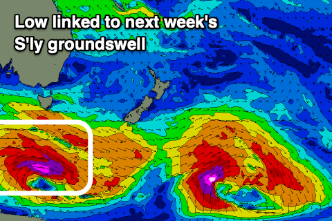
Longer term the only source of swell is a long-period and diffracted S’ly groundswell from a strong polar low moving east-southeast through our swell window early next week. Wind strengths will be significant but the track less than ideal though we should still see an inconsistent 2-3ft wave later Wednesday and Thursday morning when the swell peaks. More on this Monday though. Have a great weekend!