Easing though persistent southerly swells

Eastern Tasmania Surf Forecast by Craig Brokensha (issued Wednesday 3rd June)
Best Days: Tomorrow, Saturday, Sunday, Monday morning
Recap
Tiny yesterday but today a strong cold front pushing up and past the state is bringing a building mix of S'ly swells. We should see see south facing beaches reaching 4-5ft this afternoon but with S/SW breezes.
This week and weekend (June 4 - 7)
The swell increase from the front pushing up past us today will be fleeting and short-lived. The strongest of the front has passed and there isn't much of a tail on it.
As a result we'll see the swell ease overnight and drop further tomorrow from 3-4ft across the south swell magnets, much smaller into the afternoon.
 Conditions look great with a W tending N/NW breeze, favouring those south swell magnets.
There isn't expected to be much size left Friday over 1-2ft on the south magnets, if that.
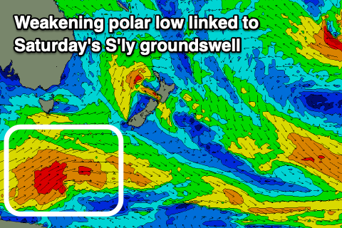
Our new S'ly groundswell for Saturday is on track, with a polar low due to form south of WA and move into our swell window tomorrow afternoon.
A fetch of gale to severe-gale W/SW winds will project east, with the S'ly groundswell due to fill in Saturday and offer 3ft+ sets across south facing beaches. Conditions are looking OK though not great for the swell magnets with a morning W/SW-SW breeze in the wake of a change Friday evening, though N'ly afternon sea breezes should favour locations across the northern end of the coast.
This change will also bring some additional weak S'ly windswell to the mix.
The easing trend will be slowed by weaker but broad polar activity continuing through our southern swell window on the weekend, with surf to 2-3ft on the south swell magnets Sunday, easing from 2ft Monday.
Winds on Sunday look favourable with morning W'ly breezes and afternoon N/NE sea breezes, similar Monday.
Longer term there isn't anything to significant besides mall diffracted S'ly groundswells from the Southern Ocean. More on this Friday though.