Swells from all directions inbound

Eastern Tasmania Surf Forecast by Craig Brokensha (issued Wednesday 20th May)
Best Days: Southern corners Friday through Sunday, Tuesday and Wednesday
Recap
Small and bumpy N/NE windswell to 1-2ft yesterday, bigger and better to 2-3ft today though bumpy again. We should see winds swing more offshore late in the day.
This week and weekend (May 21 - 24)
The windswell from today will be all but gone tomorrow as a result of the swell generating fetch moving out of our swell window around midday today.
Into Friday our new S'ly groundswell event should show across the coast. This will be generated by a strong polar low that's south-west of the state, with a fetch of severe-gale to storm-force SW winds due to form in our swell window this evening and remain so through tomorrow as the low pushes slowly east.
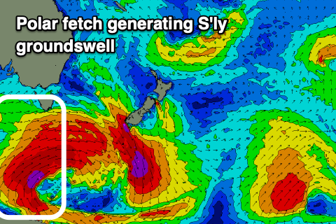 As the low continues east tomorrow evening winds will shift W/SW and out of our swell window, with the S'ly groundswell expected to be in the water from Friday through Saturday.
A peak is expected through Friday afternoon with good 4-5ft+ sets across the south swell magnets, easing slowly Saturday from 4ft or so.
Winds are unfortunately looking a little less favourable owing to a broad Tasman Low developing off the NSW coast. SW tending SE winds are expected on Friday with stronger S/SW tending S winds on Saturday.
This will limit the best surfing options to southern corners which will be smaller.
The low itself should generate some small E'ly swell for us on the weekend, off it's southern flank with a fetch of strong to gale-force SE winds just falling within our swell window Friday.
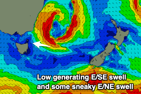 A kick to 3-4ft is expected out of the east Saturday afternoon, easing back Sunday from 3ft+, overcoming the shortfall of the southerly swell in protected spots.
S/SW tending S winds will continue to favour southern corners Sunday and Monday with smaller leftover 2-3ft waves.
Moving into Tuesday and Wednesday, a broadening but stalling nature of the low through the greater Tasman Sea from Sunday through Tuesday evening will see a good fetch of strong SE winds aimed through our swell window.
This should produce some new E/SE swell for Tuesday/Wednesday to 3-4ft or so as more favourable offshore winds kick in. We'll have to have a closer look at this Friday though but the bottom line is that there's plenty of swell on the way.