Fading south swell, building north swell

Eastern Tasmania Surf Forecast by Craig Brokensha (issued Wednesday 1st August)
Best Days: Possible south magnets dawn tomorrow, late Friday northern corners
Recap
Tiny to flat surf the last few days.
Today’s Forecaster Notes are brought to you by Rip Curl
This week and weekend (Jul 31 – Aug 5)
Want to receive an email when these Forecaster Notes are updated? Then log in here and update your preferences.
A weak front pushing across us today generated a slightly better than expected fetch of strong S/SW winds in our southern swell window, and this may have kicked up some small lines later today.
Any swell is due to peak overnight and ease from 1-2ft max at south swell magnets dawn tomorrow, tiny by lunch. W/NW tending gusty N/NW winds will keep conditions clean at these locations.
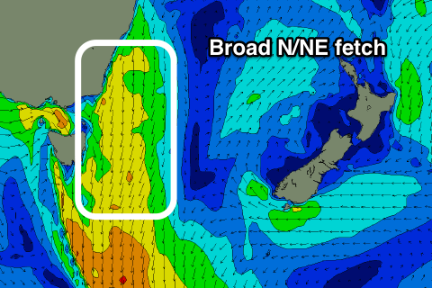 Moving into Friday and we'll see our N/NE windswell event developing through the day, with a peak now expected just before dark if not into the evening.
A strong mid-latitude front approaching from the west will squeeze a strong high in the Tasman Sea, producing a weak fetch of N/NE winds Thursday evening and early Friday, with the fetch strengthening and broadening through the day ahead of the change.
We'll likely see small building levels of weak N/NE windswell from 1-2ft at dawn, up to 3ft or so through the day, if not kicking a touch stronger on dark.
The NW change has now been delayed, with onshore N/NE winds due right up until late in the day when we may see a shift to the N/NW.
Overnight the westerly change proper will push through leaving no major size into Saturday, with fading 1-1.5ft sets max.
Looking into early next week and there's still nothing major on the cards besides a smaller and flukier N/NE windswell event late Sunday/Monday, but we'll review this Friday.