Great forecast period

Eastern Tasmania Surf Forecast by Craig Brokensha (issued Friday 1st Jun)
Best Days: Every morning over the coming period
Recap
A building though junky S'ly swell through yesterday that's cleaned up and eased just as rapidly this morning from 2ft this morning.
Today’s Forecaster Notes are brought to you by Rip Curl
This weekend and next week (Jun 2 - 8)
We're looking down a great period of swell from all angles, with a deep and slow moving Tasman Low that's currently develop due to generate swell from tomorrow through Wednesday, followed by a NE windswell event later week.
Coming back to the Tasman Low and we've seen an initial fetch of strong S/SE winds projected towards us today, producing a good SE swell for tomorrow that should build to at least 3-4ft through tomorrow with SW tending S/SE breeze.
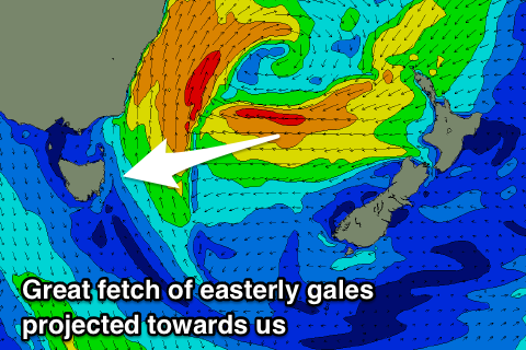 Of greater importance is the E/NE swell due into Sunday and early next week, with a great fetch of E/NE gales currently being projected towards us.
This projection will see a strong and sizey swell front generated, arriving Sunday morning and kicking wave heights to a solid 4-5ft, if not for the bigger one.
Through tomorrow we'll continue to see a great fetch of E/NE gales off the New Zealand coast, weakening and aiming more north away from us through Sunday.
This should keep moderate to large levels of E/NE swell hitting our coast into the afternoon and Monday in that 5ft range, easing quickly back from 3-4ft Tuesday morning.
Winds on Sunday morning will be great with a W/SW breeze, tending SE into the afternoon, similar Monday with a W'ly tending S/SE breeze with a shallow change.
We'll hopefully see a light morning W'ly Tuesday morning, swinging back onshore through the day.
As the E'ly swell continues to fade Wednesday, a strong high is expected to move into the Tasman Sea as a deep surface trough squeezes it from the west.
We'll see a strengthening fetch of N/NE winds developing through our swell window Wednesday afternoon and Thursday before the trough moves through Friday.
This should generate moderate levels of N/NE windswell but with average winds until the change hits, but more on this Monday.
Have a great weekend!