Good S/SE groundswell for Sunday, and NE windswell Wednesday

Eastern Tasmania Surf Forecast by Craig Brokensha (issued Friday 6th April)
Best Days: Saturday open beaches, Sunday south magnets, Monday morning south magnets, Wednesday morning
Recap
Small to tiny surf out of the south and east across the coast, but with no major quality.
Today’s Forecaster Notes are brought to you by Rip Curl
This week and weekend (Apr 7 - 13)
Inconsistent levels of E/NE trade-swell from persistent E/NE trades through our swell window north of New Zealand all week is due on the weekend.
There'll be very long waits between sets but we're looking at waves in the 2ft range tomorrow and Sunday, if not for the odd sneaky bigger one, fading through Monday.
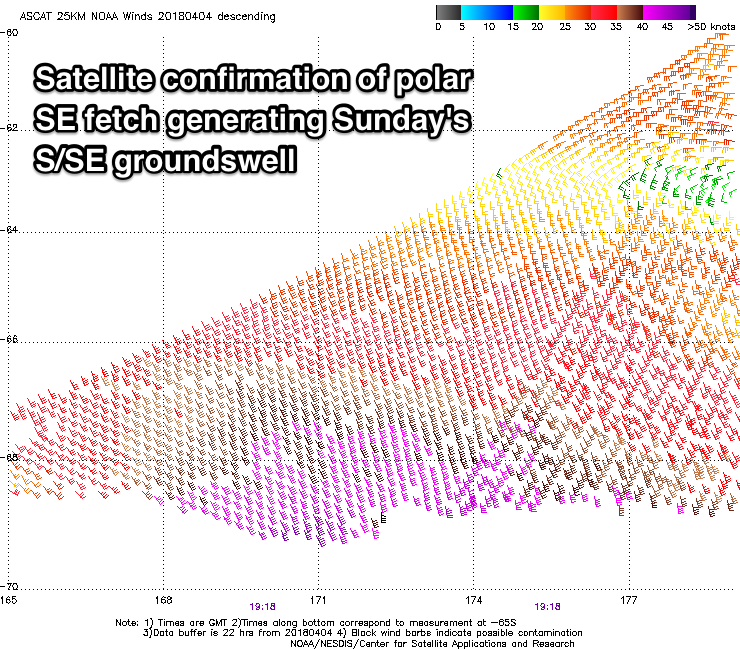 Of greater importance is the S/SE groundswell due Sunday with satellite observations confirming a great fetch of gale to severe-gale SE winds generated in our swell window, south of New Zealand.
There are a couple of 50kt barbs in the mix as well, which bodes well for a strong pulse of groundswell that's due to build later tomorrow and peak Sunday to 3ft across south magnets, with the odd sneaky 4ft bomb.
The swell is due to ease slowly through Monday from 3ft on the sets, back to a smaller 2ft Tuesday.
Conditions tomorrow will be great with a NW tending W/NW breeze, and NW tending N/NW on Sunday favouring south magnets.
Monday morning looks clean again with an early W/NW'ly but a trough moving through will bring a S/SE change.
Some weak E/SE windswell may be seen off the trough into Tuesday but only to 2ft or so and with poor N/NE winds.
Another front pushing in quickly from the west will see these N/NE wind strengthen, creating a small NE windswell for Wednesday as a W'ly change pushes through. We should see clean but fading surf from 2-3ft.
Longer term there's still nothing too significant on the cards, but more on this Monday.