Clean good swell Thursday, fading Friday

Eastern Tasmania Surf Forecast by Craig Brokensha (issued Wednesday 17th January)
Best Days: Thursday and Friday
Recap
Fun easing S/SE windswell through yesterday, while today we've got a new E/SE swell on the building. Open beaches were around 2ft+ but we should see the surf reaching 3ft later today though with sea breezes.
Today’s Forecaster Notes are brought to you by Rip Curl
This week and weekend (Jan 18 - 21)
Tomorrow and Friday will be the pick of the forecast period with a peak in E/SE groundswell and favourable winds.
Over the last day or two we've seen a very intense Tasman Low developing east of us, with a fetch of S/SE gales sitting just within our eastern swell window.
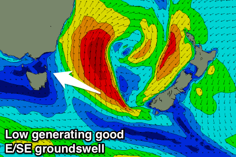 This low will weaken from this afternoon while remaining positioned to our east, with a strong pulse of E/SE groundswell due to peak tomorrow, spreading radially off the low before easing Friday.
Open beaches across the northern half of the coast should see 3-4ft+ waves most of tomorrow, easing later in the day and down from 2-3ft Friday morning.
A W/NW tending N/NW wind will keep conditions clean most of tomorrow, persisting from the NW Friday.
The E/SE swell will be all but gone on Saturday with fading 1-2ft sets, mixed in with a poor building S/SE windswell along with fresh S/SE winds.
These S/SE winds will be linked to a weak trough developing off the coast, but the fetch of E'ly winds that were due to generate some better E'ly windswell Sunday/Monday looks much weaker.
We're looking at onshore 1-2ft waves with no real power or push.
Longer term there's nothing to significant on the cards until mid-late week but more on this Friday.