Nothing of note this week, N/NE swell for the weekend

Eastern Tasmania Surf Forecast by Craig Brokensha (issued Monday 23rd October)
Best Days: Saturday north-east swell magnets
Recap
Tiny unsurfable levels of leftover NE swell on Saturday, while Sunday was also tiny, but a small S'ly swell was seen into the afternoon, holding this morning to a small 1-2ft at south magnets.
This week and weekend (Oct 24 - 29)
As touched on last update, there's no major swell due at all across our region this week with our swell producing regions being benign until the weekend.
A small fetch of SE winds wrapping around the base of a low under New Zealand looks too short-lived and small to produce any decent S/SE swell late week.
 What we'll be looking at is a broad surface low moving in from the west across the country, sitting too north of us to generate any decent swell.
A fetch of strong E/SE winds will be generated on the southern flank of this low, but just a touch too north and out of our swell window.
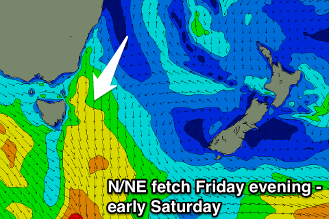
Instead a mid-latitude front pushing in from the west will squeeze a high in the southern Tasman Sea, generating a strengthening fetch of N/NE winds down our coast Friday afternoon and evening.
A small but fun pulse of N/NE swell should be seen Saturday morning to 2-3ft across north-east facing locations, easing through the day as a NW change pushes through.
We may see the fetch develop again into Sunday evening as a stronger system pushes in from the west, but this looks to be very short-lived, resulting in a smaller pulse of swell. We'll have to have a closer look at this Wednesday.