Good S'ly swells, largest Sunday

Eastern Tasmania Surf Forecast by Craig Brokensha (issued Wednesday 6th September)
Best Days: South magnets tomorrow morning, open beaches Friday and Saturday, south magnets Sunday
Recap
Tiny waves the last two days, but some new S'ly swell should have been seen this afternoon with a strong polar front pushing up and past us.
This week and weekend (Sep 7 - 10)
The strong frontal system pushing up and over us today is moving off quickly to the east and any swell generated later today and overnight will fade quickly tomorrow from 2-3ft at south magnets.
Conditions look as if they'll be offshore from the W/NW most of the day, swinging SW later.
Now, looking into Friday and more so the weekend, we've got some good large S'ly swell on the cards.
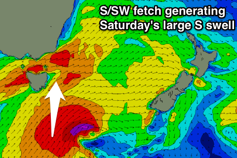 Firstly a strong polar front pushing up and past us Thursday evening and early Friday, aiming a broad fetch of strong to gale-force S/SW winds through our southern swell window.
We'll then see an embedded low forming in our southern swell window south-southeast of us on Friday afternoon and evening, projecting stronger severe-gale to near storm-force on top an active sea state.
This will generate the largest increase in S'ly groundswell for Saturday.
Firstly though, Friday should see some new mid-period S'ly swell coming in around 3-4ft across south facing beaches most of the day, but with W/SW tending SW winds.
Saturday will see similar winds, but the S'ly groundswell should come in around 6ft+ across south facing beaches, easing off through Sunday from 4-5ft with better W/NW winds.
We'll have a final look at this swell on Friday, but longer term there's nothing to major so work around this coming energy.