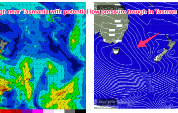
A big dominant high (1032hPa) is sitting over SE Australia, with a series of powerful fronts passing well to the south and the progression slowed in New Zealand longitudes. The high is slow moving, setting up a dichotomy with N’ly winds across temperate NSW and a more SE flow in a ridge along the sub-tropics. Across all regions we’ll see pulses of S’ly groundswell this week from the deep fetches located in the Far Southern Tasman.
Primary tabs
/reports/forecaster-notes/sydney-hunter-illawarra/2023/09/11/light-winds-and-sly-groundswell-pulses
freeride76
Monday, 11 September 2023
/reports/forecaster-notes/sydney-hunter-illawarra/2023/09/08/fun-sized-s-swells-weekend-getting
freeride76
Friday, 8 September 2023
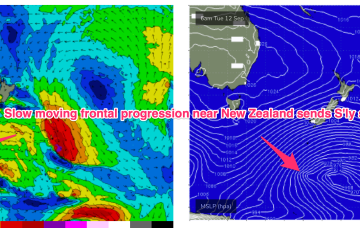
The headline act is a complex low system approaching Tasmania with an embedded front and linked to a long inland trough. A NE-E/NE infeed into this system has produced swell from that quarter and as the low clears the swell shadow of Tasmania we’ll start to see swells from the S. Following systems next week look to generate stronger, longer period S’ly swells.

/reports/forecaster-notes/sydney-hunter-illawarra/2023/09/06/good-options-end-the-week-plenty-sizey-s
freeride76
Wednesday, 6 September 2023
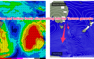
A front and small low are now racing across the Tasman with a high over NSW moving into the Tasman and directing a freshening N’ly flow across most of the Eastern Seaboard. So far, so spring. A complex low, front and trough then approaches from the W, bringing a flush of W’ly winds and a S swell.
/reports/forecaster-notes/sydney-hunter-illawarra/2023/09/04/few-options-work-week-potential-s-swells
freeride76
Monday, 4 September 2023
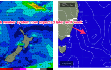
The following system expected over the weekend now looks a little stronger and under current modelling is expected to be a source of fun sizey S swell, potentially with several large pulses into next week.

/reports/forecaster-notes/sydney-hunter-illawarra/2023/08/31/winter-goes-out-whimper-quiet-start
freeride76
Friday, 1 September 2023
No great change to the weekend f/cast. S swells will be the dominant force in the water through tomorrow, mostly mid period stuff whipped up by a proximate fetch of S-SSW winds generated by a front and trough of low pressure forming in the Tasman.

/reports/forecaster-notes/sydney-hunter-illawarra/2023/08/30/low-in-the-tasman-start-spring-another
freeride76
Wednesday, 30 August 2023
There’s a troughy pattern in play at present, with a long trough snaking from inland QLD down to the Central/Southern NSW Coast. Return flow off the back of a retreating high is feeding N’ly winds into the trough line. We’re expecting a front to interact with the trough overnight Thurs to form a low pressure trough in the Tasman.
/reports/forecaster-notes/sydney-hunter-illawarra/2023/08/28/low-pressure-in-the-tasman-kick-spring
freeride76
Monday, 28 August 2023
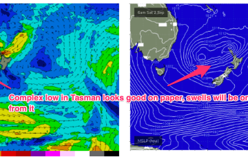
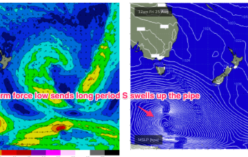
A trough will extend along the East coast before a front through the latter half of the week brings vigorous S’ly winds by Fri. The trough is expected to move offshore and merge with a more tropical derived depression to form a large trough of low pressure in the Tasman over the weekend. This has been a feature of synoptic prognostic charts for a few weeks now, with forecasts generally tending to weaken and fall apart as the event unfolds. Lets hope this one comes to fruition to deliver some chunky S-SE swell.
/reports/forecaster-notes/sydney-hunter-illawarra/2023/08/25/long-period-s-swells-keep-coming
freeride76
Friday, 25 August 2023
We’ve still got the basic building blocks in place that we mentioned on Wed with the proviso that everything looks a little weaker and disjointed. High pressure moves NE of Tasmania and the troughs remain inland, although we may see a weaker trough area move off the North Coast of NSW early in the week.
/reports/forecaster-notes/sydney-hunter-illawarra/2023/08/23/small-flukey-swells-the-weekend
freeride76
Wednesday, 23 August 2023
A cold front and long trough are bringing a S’ly change to the NSW coast, extending into the sub-tropics later today and overnight. There’s not a great deal of useful swell generating winds associated with the change so only modest short range S swells are expected to accompany it.
/reports/forecaster-notes/sydney-hunter-illawarra/2023/08/21/quiet-week-ahead-potential-unruly
freeride76
Monday, 21 August 2023
The remnants of the weekends frontal systems have set up a fading off axis fetch near New Zealand with the current run of small S swells also on the way out. A weak mid week front will bring a wind change and a small flush of S swell but next week looks a bit more robust although with plenty of winds.