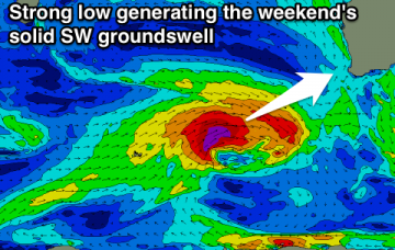
Summer swells and winds ahoy!
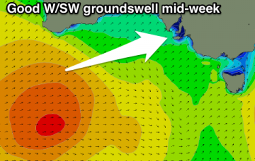
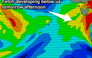
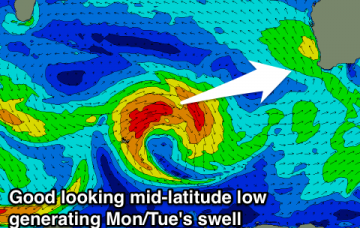
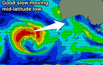
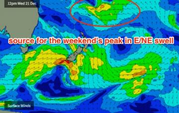
This swell is expected to reach maturity around Wednesday or Thursday, which means we’ll probably see a peak in size around Saturday or Sunday.
Easing W/SW swell tomorrow morning with offshore winds, smaller Wednesday as good winds persist. Average end to the week ahead of a strong new swell on the weekend.
Mix of W/SW swells building tomorrow, biggest later and peaking Wednesday with a S/SE breeze. Cleaner into Thursday but small and easing. Weekend is generally small, while a good W/SW swell is on the cards for Boxing Day.
Average tomorrow, with a good mix of moderate sized W/SW swells for Wednesday as winds deteriorate. Lingering onshores Thursday as the swell eases, cleaner to the east Friday and Saturday.
From late Monday or Tuesday onwards, we will also start to see a building E/NE swell originating from a broadening E'ly fetch around the southern flank of TD04F (a tropical depression currently delivering a deluge to Fiji) which may be upgraded to a Category 1 Tropical Cyclone this evening.
The models are a little more confident for a fun NE swell on Saturday than I am.
Flukey NE swell tomorrow and S'ly swell late Sunday. Better chance of surf Tuesday with a N/NE windswell and westerly change through the day.
Tiny most of tomorrow ahead of a late kick in swell, peaking Sunday morning with westerly winds. Tiny and clean Monday with some new W/SW swell mid-late week but with dicey winds.
Small mid-period swell for tomorrow with fresh easing offshore winds, average Sunday. Solid W/SW groundswell filling in Monday, cleaner and easing Tuesday.
Average tomorrow with fun peaky waves on the South Coast Sunday morning. Cleaner and better Monday morning. Strong W/SW swell for later Tuesday and Wednesday with less than ideal winds.