Rapidly improving surf tomorrow, windy and easing Wednesday

Western Australia Surf Forecast by Craig Brokensha (issued Monday 5th October)
Best Days: Rapidly improving tomorrow morning, Wednesday morning out of the wind, Friday morning, Saturday morning
Recap
Pretty average weekend of waves and performance by the Eagles as well. Nothing to really get stuck into with onshore winds but plenty of swell.
This week (Aug 6 - 10)
Today's large increase in groundswell will be reinforced by a secondary W/SW pulse tomorrow, linked with the frontal system currently pushing across the state.
The South West should continue to provide easy 10-12ft sets through the morning, easing a touch later in the day, with 3ft sets up around Perth.
A ridge of high pressure will move in quickly tomorrow resulting in winds swinging from the S/SE at dawn around to the E/SE through the day across both regions, with variable breezes likely into the afternoon.
Therefore the early morning session is probably worth leaving, with the mid-late morning sessions providing the cleanest and straightest conditions.
A drop in size is due through Wednesday but a reinforcing SW pulse is due into the afternoon from a less than favourably aligned fetch of NW gales to our south-west. This will just soften the easing trend a touch.
Stronger E/NE winds will create tricky conditions Wednesday, tending more N/NE through the middle of the day before easing into the afternoon from the N'th.
A shallow change is due into Thursday with local S/SE winds around Margs and likely E/NE breeze still around Perth before giving into S/SW sea breezes. The swell will be slower and around 3-5ft in the South West, with a slight kick in size through the afternoon from the backside of the pre-frontal NW fetch. Perth should see inconsistent 1-2ft sets all day.
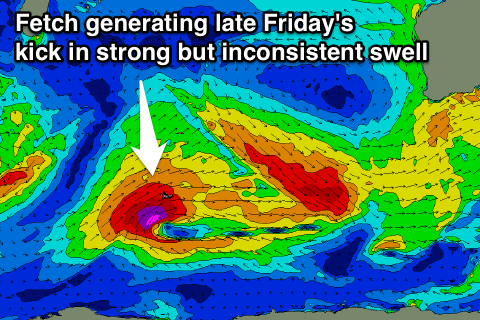 Similar size waves are due into Friday, but later in the day a long-range and inconsistent SW groundswell is due. This is being created today and through tomorrow from the initial stages of the frontal system producing Wednesday/Thursday's swells.
A fetch of severe-gale to sub-storm-force SW winds are due to be projected north-east towards Indonesia. Inconsistent but strong 5-6ft sets are due later Friday in the South West from this source, with 1-2ft waves in Perth, easing back from 4-5ft and 1-1.5ft respectively Saturday morning.
This weekend onwards (Oct 10 onwards)
Less than ideal S/SE winds and small to moderate amounts of swell look to limit surfing options this weekend.
There's not much in the way of size due with background energy in the 3-4ft range across the South West and 1ft in Perth due after Saturday morning's easing surf.
Longer term there's some fun but inconsistent W/SW swell energy due into next week, but we'll look at this closer on Wednesday.
Comments
Now's here's a bloody big set at The Bubble! Biggest I've ever seen on the cam.
Incredibly windy offshore conditions this morning. Looks pretty speccy on the cams though!