More tempestuous weather ahead with a chunky NE swell as a low drifts down from the Coral Sea

freeride76

More tempestuous weather ahead with a chunky NE swell as a low drifts down from the Coral Sea

freeride76

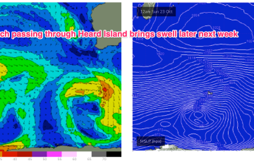
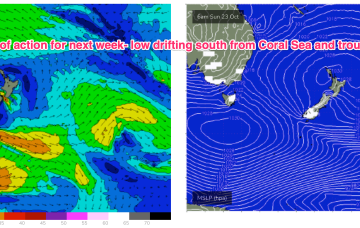
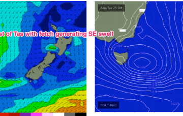
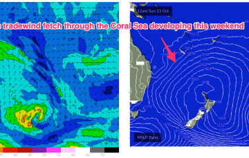
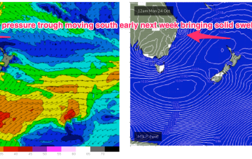
A trough of low pressure off the QLD Coast forms a small surface low over the weekend and this moves south Mon, interacting with a strong high moving south of Tasmania and another interior low forming in a trough line late in the weekend. This potent brew intensifies the NE-E/NE fetch forming in the Coral Sea and drags it south, where it more directly impacts temperate NSW. 

Lots of size expected from the NE and E under a dynamic pattern

freeride76

Lots of size expected from the NE and E under a dynamic pattern

freeride76

The onshore flow is enhanced into a deeper tradewind flow up in the Coral Sea, which gets a boost from a trough of low pressure expected to form off the Central QLD Coast this weekend before drifting south as a surface low, bringing sizey swell from the East and dynamic weather. The trough of low-pressure from inland Victoria is expected to drift SE of Tasmania over the weekend with plenty of swell expected.

E swell now looking very sizey as low forms in Coral Sea and drifts close to SEQLD

freeride76

E swell now looking very sizey as low forms in Coral Sea and drifts close to SEQLD

freeride76

The onshore flow is enhanced into a deeper tradewind flow up in the Coral Sea, which gets a boost from a trough of low pressure expected to form off the Central QLD Coast this weekend before drifting south as a surface low, bringing sizey swell from the East and dynamic weather.

Lots of swell incoming, most of it from the NE- with some tricky wind changes to deal with

freeride76

Lots of swell incoming, most of it from the NE- with some tricky wind changes to deal with

freeride76

We are in between patterns at present with a feeble trough delaying the start of the next pattern. That will see an approaching inland low and high pressure system generate increasing NE winds across most of the Eastern Seaboard. The onshore flow is enhanced into a deeper tradewind flow up in the Coral Sea, which gets a boost from a trough of low pressure expected to form off the Central QLD Coast this weekend. All of which is to say the dominant swell trains will be from the NE to E/NE through the short to medium term.

A few small windows this week as E swell fades out, with chunky Tradewind swell on the radar from this weekend

freeride76

A few small windows this week as E swell fades out, with chunky Tradewind swell on the radar from this weekend

freeride76

As mentioned last week we have a weak, troughy pattern in the Tasman with a broad area of high pressure now moving over the area and yet another complex low pressure system moving East across inland Australia. A series of fronts are rapidly transiting across the Lower Tasman with some small S swell pulses en route. A last pulse of E swell generated in the South Pacific is due this week.