Strong south swells for Northern NSW, and windows of good winds
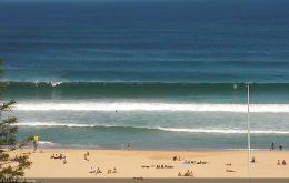
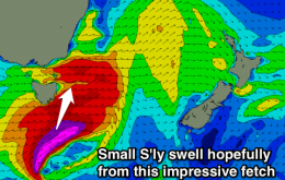
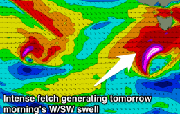
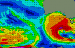
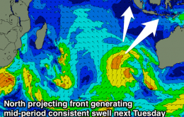
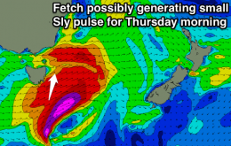
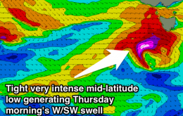
We’ve got a complex week of multiple south swells ahead.
We have several new pulses of south swell due over the coming 36 hours, courtesy of a vigorous front and low passing across Tasmanian longitudes.
Flukey acute south swell possible for tomorrow at south magnets, nothing significant from then on besides a weak N/NE windswell.
Solid W/SW swell early tomorrow, easing rapidly under offshore winds, tiny Friday morning. New W/SW swell late in the day, peaking Saturday with average conditions, fading Sunday.
Onshore winds and new swell tomorrow, easing Friday and clean early in the South West. Onshore weekend with a large mid-period swell building Sunday, easing early next week as conditions improve.
Good new SW groundswell tomorrow with offshore winds down South, easing Friday with a morning W/NW'ly. New swell Saturday with an E/NE breeze, cleaner Sunday but small and easing. Large swell for early next week.
New W/SW-SW groundswell for tomorrow with offshore NW winds, easing Friday with good winds for the Torquay region during the morning. Fun W/SW swells all weekend, but average Saturday and best on the beaches Sunday. Large new W/SW swell developing for next week.
Easing S/SW swell over the coming days ahead of a new inconsistent S/SW groundswell for Friday. Smaller SW swells for the weekend then a mid-period consistent SW tending S/SW swell from Tuesday.
No decent swell with, some small possible S'ly swell lines across magnets Thursday morning.
Small W/SW swell for Wednesday morning, with a much better W/SW swell for Thursday morning. Small waves for the weekend.