Make the most of today, hit the beaches on the weekend

Victorian Surf Forecast by Craig Brokensha (issued Wednesday 24th August)
Best Days: Today protected spots, Friday morning, Saturday, Sunday exposed beaches, Monday afternoon, Wednesday
Features of the Forecast (tl;dr)
- Slight drop in size tomorrow, steadying though with reinforcing mid-period SW energy, holding Fri
- Fresh SW tending weaker S/SW winds tomorrow (likely W ealy on the Surf Coast), variable Fri morning ahead of PM S/SE winds
- Mid-period SW swell for Sat AM, easing slightly later and further Sun
- N/NE tending E/NE winds Sat, fresh N/NE winds Sun
- Inconsistent, long-period W/SW groundswell arriving Mon PM, biggest later with strong N/NE winds, easing and tending N/NW near dark
- Easing groundswell Tue with strong S/SW tending SW winds
- Mid-period SW swell Wed with NW winds
Recap
A good kick in size across the state yesterday but with generally raw to stormy conditions, best in protected spots early for the keen but nothing amazing
Today conditions have cleaned up and the swell is much more organised with pumping 4-5ft waves on the Surf Coast and protected spots to the east. The best day of surf in a long while. Winds will remain favourable all day from the W/NW, so make the most of it as onshore breezes will kick in tomorrow.

Looking the goods this morning
This week and weekend (Aug 25 - 28)
We're half way through our Southern Ocean swell episode and with great conditions expected all day today in protected spots ahead of an onshore change tomorrow as a cold front clips us. Winds will shift fresh SW tomorrow morning, easing through the morning and tending S/SW along with a drop in size from today. There's a chance for early W'ly winds on the Surf Coast but it'll be raw and nothing like today, so make the most of it. The late afternon will likely be fun on the Surf Coast as winds continue to ease.
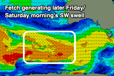 Swell wise, some new, mid-period SW swell is expected to fill in through the day, followed by a secondary pulse Friday and then third smaller pulse Saturday.
These reinforcing swells are being generated by weaker but healthy fronts moving in behind the progression linked to the last two days of swell. The next two day's swell has been generated by strong to near-gale-force W/NW tending W winds swinging in from east of Heard Island and should maintain 4ft sets across the Surf Coast with 6ft sets to the east tomorrow and Friday.
Saturday's looks a touch smaller, generated by a similar but slightly weaker W/NW fetch. 3ft surf is generally expected across the Surf Coast, 4-5ft to the east but there still might be the odd 4ft bomb on the magnets to the west in the morning.
Looking at the local winds and variable breezes are due into Friday morning as a high starts to shift in from the west, likely light W/NW on the Surf Coast, tending S/SE through the day and E/SE to the east, tending S/SE through the day.
The weekend will be cleanest and best with a N/NE tending E/NE breeze, possibly giving into late SE winds but we'll confirm this Friday. Sunday will see smaller, easing surf from 2-3ft on the Surf Coast and 4ft+ to the east with great, fresh N/NE winds.
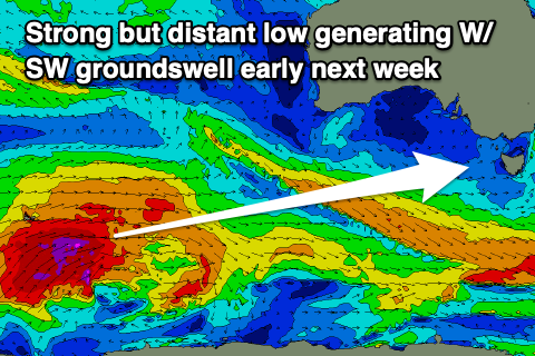 Moving into next week and we've got a low point in swell Monday morning ahead of an inconsistent, moderate sized long-period W/SW groundswell arriving into the afternoon and peaking overnight. Winds will strengthen from the N/NE, easing and tending N/NW later in the day ahead of a strong S/SW change Tuesday.
Coming back to the swell generator and an initial polar low has formed south-east of South Africa, but we'll only start to see a favourable swell generating fetch from this system once it nears Heard Island tomorrow. Once it does, a great fetch of severe-gale to storm-force W/SW winds are forecast to be generated, initially favourably in our swell window before projecting north-east towards Western Australia and more into our western swell window.
The storm will weaken rapidly once pushing east towards the Bight, with the long-period forerunners due to arrive later morning Monday with building sets into the afternoon, likely reaching 3-4ft by dark on the Surf Coast and 6ft to the east. Unfortunately Tuesday looks poor as the swell eases from a similar size with that S/SW breeze, cleaner Wednesday with NW offshore breezes and some fun reinforcing mid-period SW swell.
Longer term there's still a bit of healthy activity on the way which is good to see. More on this Friday.
Comments
Yeah wow that was different. So chunky you could carve it.
Noice!
I'd say 4-5 was on the money with the sets Craig. Got one with the lip right on the head paddling out and I paused for a second, like I was unfamiliar with what it was and what was about to happen. Session was nice, lots of cutties and carves. Now I just have to stall traveling a while so I can enjoy these waves that have finally come back. Let me know when the run is over :)
Yeah awesome, how is that shock after battling against weak, small surf to then have a powerful proper wave coming in at you or paddling into. Yeah a fun run indeed.
Epic day!
I had a classic case of paddling out at a fairly queit spot, sitting in a bit, then thinking I could esily stroke into a bomb all nonchalant like. Didn't make it past the lip and ended up diving for crays among the kelp. It was litrerally a month since surfing anything over 2...maybe 3ft. A welcomed change that's for sure.