Fun week of waves ahead, before a winter onslaught

Victorian Surf Forecast by Ben Matson (issued Monday May 11th)
Features of the Forecast (tl;dr)
- Low point in size Tues, clean with light winds, best for exposed beaches
- Strong new swell Wed/Thurs with good waves at most coasts, easing Fri, generally light variable winds (E'ly if anything)
- Smaller and very windy weekend ahead, give it a miss
- Large windy swell Mon (protected spots only), easing Tues
- Strong swells to persist later next week and into the weekend
Recap
Fun surf west of Melbourne over the weekend with predominant W'ly airstream veering W/NW or NW at times, and surf size pulsing in and around the 3-4ft mark. Too wind affected for the open beaches east of Melbourne and not really enough size for protected spots. Smaller today as winds ease back to a light N'ly, offering good options almost everywhere though starting to really slow down on the Surf Coast.
This week (May 10 - 13)
Generally light variable winds all week should keep conditions clean across all coasts. If anything, we'll see the trend veer to the east though no major strength is expected west from about Wilsons Prom (eastern Victoria will see freshening E/NE winds though).
While this is great for the open beaches east of Melbourne, we just need to bear in mind there may be occasional brief periods west of Melbourne where conditions become a little ruffled.
As for size, the current easing trend will bottom out into Tuesday, favouring exposed spots.
A new groundswell will arrive on Wednesday, sourced from an impressive though slightly off-axis low well south of WA over the weekend. Swell direction will have a little more west in it than is ideal, however it was a broad, slow moving system and should produce good 3-4ft sets across the Surf Coast (wouldn't rule out the odd bigger set at the swell magnets) and 5-6ft+ surf east of Melbourne, which will slightly overpower the open beaches at times.
Modest secondary fronts trailing behind the main low pressure system will slow the easing trend from Thursday, so expect a similar size range early, abating gradually into the afternoon and then further into Friday - perhaps only down by a foot or so at both coasts by the end of the week.
Either way, there’ll be good conditions and strong swells across both coasts for at least Wednesday and Thursday, and even Friday should produce a broad range of options throughout the state. So, there’s no need to hone in on specific time frames around early windows of favourable winds or swell spikes - take your time and plan your session around your preferred size/tide combo.
This weekend (May 14 - 15)
Looks like an average weekend ahead with strengthening pre-frontal N’ly winds Saturday tending gale force W/NW on Sunday.
Whatever leftover swell we see on Friday will rapidly diminish into the weekend; there’s a new swell due to glance the region but it’ll be small in size and with a healthy westerly component, which will limit wave heights across those coasts offering protection from the wind.
The leading edge of a powerful new swell is due to arrive late Sunday but we probably won’t see an appreciable increase until after dinner time.
So, if you’ve got a choice, flag this weekend and aim to get a session in mid-late this week instead.
Next week (May 16 onwards)
We’ve got a classic winter pattern ahead, with a vigorous front expected to cross the state early next week.
And, it may become supercharged thanks to a tropical infeed, courtesy of TC Karim - way out near the Cocos (Keeling) Islands at the moment - which is expected to move south and eventually merge (as a weakened tropical low) with the broader frontal system associated with Monday's change.
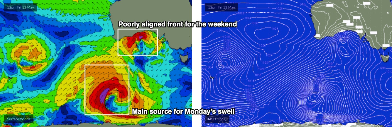
Indeed, the parent polar low to Monday's front looks very juicy on the charts: we'll see plenty of size and long periods (in the 17-18 second range) lighting up the entire southern Australian coast with strong swells. But there'll be a lot of noisy windswell in the mix from local sources too.
So, expect a lot of size and a lot of wind from the western quadrant to kick off proceedings next week. It’ll certainly only favour sheltered spots only to begin with; sets should easily reach the 6-8ft mark throughout Torquay though most locations will be blown out.
Looking further ahead, and a winteresque conveyor belt of low pressure systems are set to deliver several strong swell events behind this (mid-late next week and the following weekend), with pockets of more favourable winds on hand.
More on this in Wednesday’s update.
Comments
Nice work Benny! Winter onslaught - I like these words :) New Yulex suit and quiver has expanded 5 boards in recent weeks. Can’t wait yyyyiiiiiiippppp
Running the Great Ocean Road Half Marathon on Sunday. Can’t wait to run directly into gale strength winds :)
That does not sound fun at all. Running is bad enough already, well for me anyway.
Nice, some motion in the ocean by the sounds of it.
That sounds like good news for those who favour W.P.. I need to get my car fixed ASAP !
I like supercharged
Supercharged, Turbocharged, Ludicrous mode… I’ll go with any :) C’mon Karim, give it the 3 revs. I’m egging you on to merge at autobahn speeds
One fellow I knew had a Datsun 180B and got me to drive him home one night when he was blind drunk. He kept egging me on to 'foot to the floor till you hear the click!' - which was the point where the auto shifted down on the gutless bastard. This was his equivalent to ludicrous mode.
Now that's a great read
Hey Ben, the new groundswell arriving wednesday will that be am or pm? No sign at sorrel as yet so I'm assuming it will be pm...
Fun little waves so far.