Good swells with light winds

Victorian Surf Forecast by Craig Brokensha (issued Wednesday 23rd March)
Best Days: Tomorrow morning, Saturday morning selected spots east of Melbourne, Sunday
Features of the Forecast (tl;dr)
- Moderate sized, mid-period SW swell tomorrow with light morning W/NW winds on the Surf Coast, variable to the east
- Slight drop in size Fri with light S/SW-S winds, increasing (possible W'ly winds early on the Surf Coast)
- Late increase in SW swell Fri, with a stronger S/SW groundswell Sat with light-mod E/SE tending fresh S/SE winds
- Good, reinforcing SW groundswell arriving mid-late morning Sun with light N/NE tending SE winds to the east, N/NW tending E/SE to the west
- Easing SW groundswell Mon with gusty S/SW winds as a trough moves through
Recap
A good and unexpected pulse of mid-period S/SW swell on Monday afternoon provided punchy waves with light to moderate onshore winds, but this eased as quickly as it arrived leaving weaker, smaller waves yesterday morning with clean conditions on the Surf Coast, a little lumpy and bumpy to the east.
Today a mix of new swells are on the build with 2-3ft sets on the Surf Coast and 3-4ft waves to the east, cleanest across the Surf Coast before winds shift strong SW over the coming hours.
This week and weekend (Mar 24 – 27)
Today's strengthening SW wind will be linked to a broad but relatively weak cold front clipping the state, bringing some fun sized, mid-period SW swell to the region tomorrow.
Consistent 3ft waves are due on the Surf Coast with the rare bigger one on the swell magnets, coming in at 4-5ft to the east.
Conditions are looking favourable for both coasts with winds easing overnight and tending light W/NW on the Surf Coast tomorrow morning, variable to the east. With the easing onshore winds and variable breezes to the east expect a bit of lump and wobble across locations east of Melbourne.
Friday should hold around 2-3ft and 4ft+ respectively across both coasts as some reinforcing mid-period swell fills in but winds look a little dicey and light from the S/SW-S. The Surf Coast may see a light morning W'ly but don't rely on it.
We then look at our mix of mid-period SW swell and S/SW groundswell for Saturday, followed now by a reinforcing SW groundswell on Sunday.
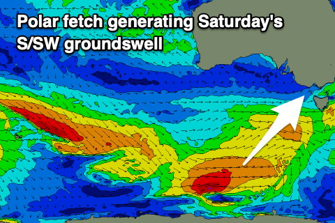 These swells will be generated by a healthy polar frontal progression that's started to take shape under the country with a pre-frontal fetch of strong W/NW winds that's pushing under the Bight due to be followed by strong to gale-force W/SW winds on the polar shelf.
The pre-frontal fetch will generate some mid-period energy for later Friday and Saturday morning, with the polar fetch generating the best pulse of S/SW groundswell that now looks to be in the water from dawn Saturday.
Behind this polar fetch, an additional strengthening frontal system will generate a great fetch of W/NW gales, producing a reinforcing pulse of moderate sized SW groundswell through Sunday.
Size wise the Surf Coast should see 3-4ft sets with 4-6ft surf to the east and winds look a bit dicey with a light to moderate E/SE breeze now due ahead of fresh S/SE sea breezes.
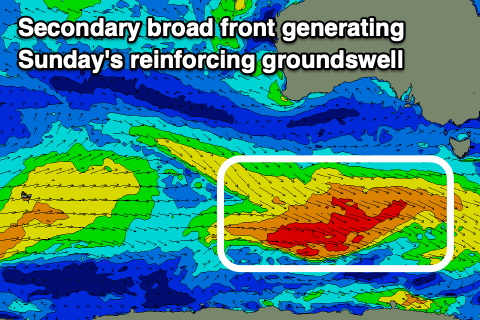 Sunday looks cleaner as winds shift from a dawn E/NE'ly to the N/NE through the morning (N/NW on the Surf Coast) ahead of sea breezes. The new SW groundswell should maintain 3-4ft waves on the Surf Coast and 5-6ft sets to the east with it filling in mid-late morning and holding into the afternoon.
Come Monday a surface trough looks to move in around dawn, bringing S/SW winds and poor conditions as Sunday's SW groundswell eases.
Following this it looks like mid-latitude systems will dominate our swell window into the middle to end of next week, bringing dicey winds but a couple of varying swell pulses. More on this in Friday's update.
Comments
Mmm, that's sounds a little better Craig
Give it to me Craigy! Uh huh uh huh!
Yeah thanks, now I've got an earworm I can't dislodge.
And all the girlies say craigos is pretty fly for a white guy!
Haha, fark me, literally laughing.
Slight pulse in my pants today, cheers Craigos, it's a start
Happy World Meteorological Day for today Craig. Were you excited?
Not wrong about Mondays unexpected mysto swell. It was on the pump with Indo like glassy conditions


Wow. On the cook. Great shots.
Thanks Bnkref, trick photography mainly closeouts ;) Nah there were some rippers rolling through and almost eerily quiet
Incredible.
Conditions that really just make ya happy Craigos. It was dreamy