Nothing special this week, better weekend

Victorian Surf Forecast by Craig Brokensha (issued Monday 21st March)
Best Days: Tomorrow morning exposed beaches, Thursday morning Surf Coast for the keen, Friday on the beaches for the keen, Saturday and Sunday mornings on the beaches, Monday morning on the beaches
Features of the Forecast (tl;dr)
- Small mid-period SW swell tomorrow with variable tending S/SE winds ahead of an evening SW change
- Building mix of swells Wed with fresh SW winds (possibly W'ly for a period in the AM on the Surf Coast)
- Peak in mid-period SW swell Thu with light S/SW tending S winds (likely W'ly for a period early on the Surf Coast)
- Easing SW swell Fri with light S/SE winds, increasing
- New mix of mid-period SW swell and building S/SW groundswell Sat with E/NE tending fresh SE winds, easing Sun with similar winds
Recap
A mixed weekend of surf, improving rapidly across the Mornington Peninsula and Phillip Island during Saturday morning as winds shifted E/NE and then variable out of the N/NE. A new, moderate sized mid-period W/SW swell provided 4ft+ waves to the east with a mix of SE windswell across the Surf Coast to 3ft but poor conditions.
Yesterday provided cleaner conditions across the Surf Coast, best on the beaches with a mix of swells to a slower 2-3ft, with 3-4ft sets to the east.
This morning the surf is a touch smaller again and E/NE winds are favouring the exposed beaches.
This week and weekend (Mar 22 – 27)
After a few days of fun waves across the beaches, we've got one more morning of workable waves before winds create a few issues into the middle to end of the week along with weak levels of mid-period swell.
There'll be surf this week but lower those expecatations.
Tomorrow morning winds should be variable across all locations along with a small, reinforcing mid-period SW swell, maintaining 2ft waves on the Surf Coast and 3ft+ sets on the Mornington Peninsula. Afternoon S/SE sea breezes will freshen into the afternoon ahead of an evening SW change as a trough moves in from the west.
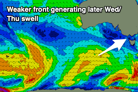 This trough will be associated with a weak frontal system pushing up and towards us over the coming days, generating a new, mid-period SW swell for later Wednesday but more so Thursday.
The trough will keep fresh SW winds blowing through Wednesday (possibly tending W'ly for a short period around Torquay in the morning), but with the low quality swell it won't be anything special.
Winds should abate into Thursday but be out of the S/SW. There's a good chance for early light W'ly winds around Torquay but I'll confirm this Wednesday. The mid-period SW swell should peak in the 3ft range on the Surf Coast (rare bigger one) Thursday with 4-5ft sets to the east, easing into Friday with light S/SE winds.
So while not perfect there should be some OK waves for those who aren't too fussy.
The weekend is looking better on the beaches with an improvement in winds, shifting E/NE each morning along with a new, mix of mid-period SW swell and S/SW groundswell.
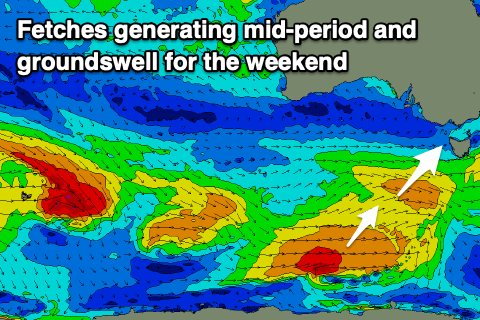 The source of these swells will be a healthy fetch of strong to gale-force winds behind the weak front projecting towards us over the coming days. The stronger gale-force fetch will be at a more polar latitude, generating the S/SW groundswell component.
The mid-period energy should be in the water at dawn with the groundswell arriving mid-late morning.
The Surf Coast should build to 3ft to occasionally 4ft with the Mornington Peninsula coming in at 4-5ft though with the groundswell there might be the rare bigger one. The size will ease Sunday from 3ft on the sets across the Surf Coast and 4ft+ to the east with those favourable morning winds.
Longer term the models diverge regarding a stronger SW groundswell for late Sunday but more so Monday but either way we should see a new bump in size with what looks to be favourable winds for the beaches as a broad mid-latitude low forms across the country to our west. More on this Wednesday.
Comments
Lower the expectations.. they’re rock bottom now..
It’s nearly April and the south easterlies are still rampant, what the hell is going on
Have a read of this.. https://www.swellnet.com/news/swellnet-analysis/2022/03/17/nina-wont-budge
Hey Craig since this la nina won’t budge and these winds and swell aren’t on the horizon for the surf coast thinking heading up to sunshine coast over easter what are chances of getting waves up there? Higher probability than staying home ?
I saw Jack Robbo out at one of the Surf Coast spots yesterday having a grovel (and ripping). Thought to myself things don't look good long term for the comp. Hope I'm wrong but can't see it being a strong 6ft + swell pouring through the Bowl.
I'm just happy to see some W's instead of endless E's in the forecast winds. It gives the SC a chance at some reasonably clean conditions at protected spots at least. The Eastcoast and PI have had plenty of decent days by the look of things. It is hard to believe we might go the whole first month of Autumn without one day of good swell and offshores on the reefs.
Daddy always said cyclone season ends in april
ha
couple of chunks out there in the wind after work
Yeah I saw. I missed that one. Not sure the source.
Perhaps the bar has been lowered so far, some Vic crew have gone and built an orgone generator, a la Wilhelm Reich...
Winds don’t go west on the Ninch until the campers leave Anthony’s Nose. Always has been, always will he.
Never understood that camping spot, both with the Shire allowing it and sleeping meters from a busy road POV
Weekend looks good. Consistent swell for a week. Early Autumn looks ok to me.
This is the worst March for surf conditions at W.P. I can recall for some years indeed.