Beaches continue to provide

Victorian Surf Forecast by Craig Brokensha (issued Wednesday 16th March)
Best Days: Today, Saturday selected spots east of Melbourne, Sunday morning, Monday and Tuesday mornings exposed beaches
Features of the Forecast (tl;dr)
- Small to tiny, fading mid-period S/SW swell tomorrow with NE winds, tending variable ahead of a late SW change
- Freshening S winds Fri with a late pulse of new, mid-period W/SW swell
- Mid-period W/SW swell peaking Sat with gusty E/SE winds, easing early PM and then strengthening later from the SE
- Inconsistent, reinforcing W/SW groundswell filling in Sun with light NE tending SE winds
- Easing mix of swells Mon and Tue with NE tending SE winds Mon, N tending SW Tue
Recap
Great surf across the beaches yesterday with a reinforcing pulse of mid-period SW swell and S/SE windswell to 3ft on the sets across the Surf Coast, 4ft+ to the east.
Today the swell is easing but still a fun 2ft on the Surf Coast and 3ft+ to the east with clean conditions across all locations.

Glass this morning
This week and weekend (Mar 17 – 20)
We'll see the current swell continuing to fade into the end of the week, becoming small to tiny tomorrow under a N/NE offshore. A surface trough will bring a weak SW change into the evening, poor Friday with a freshening S'ly breeze.
The Surf Coast will be tiny tomorrow and only 1-2ft to the east.
Moving into the weekend a new pulse of W/SW swell is due, but it looks to now be a little weaker and more mid-period energy owing to the mid-latitude frontal progression linked to it now due to be a touch weaker.
This frontal progression is currently pushing up and under Western Australia but it's got ahead of itself slightly, drawing out in length but as a result, weakening in overall strength.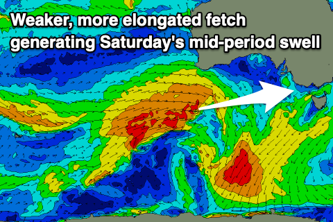
This will see a fetch of strong to near gale-force fetch of W/SW winds projected through our western swell window, weakening while dipping south-east tomorrow and breaking down instead of forming a stronger polar low.
All in all this equals a downgrade but with winds due to be out of the eastern quadrant this is good news for the beaches east of Melbourne. The Surf Coast was going to be onshore in any case.
We should see the mid-period swell arriving later Friday but peaking Saturday to 3ft mostly on the Surf Coast (odd bigger one magnets) and 4-6ft on the Mornington Peninsula. Winds are tricky and will favour selected spots with a gusty E/SE breeze kicking in Saturday morning, easing early afternoon before shifting SE into the late afternoon/evening.
Sunday looks cleaner and better with variable tending light offshore winds along with a temporary drop in energy through the morning ahead of our inconsistent, reinforcing W/SW groundswell arriving late morning. This swell is being generated by a poorly structured by stronger low pushing in behind the mid-latitude front, generating a tight fetch of W/NW gales.
Inconsistent 3ft sets are due to hold on the Surf Coast (2-3ft mostly) with 4-5ft sets to the east under the variable breeze, giving into mid-afternoon S/SE sea breezes.
Monday looks great on the beaches again with a light NE offshore and easing 2ft to possibly 3ft waves on the Surf Coast, 4ft to the east.
The surf looks to ease further through Tuesday and a trough will bring a shift in winds, from the N'th to SW into the evening. Target the morning on the beaches.
Longer term there's a bit of mid-latitude activity due through early to mid-next week with a localised increase in weak W/SW swell likely Wednesday/Thursday but we'll have a closer look at this on Friday.
Comments
Ah wow, a hyped up monday forecaster notes into a Wednesday downgrade. This is new!
Not really and as I said the beaches were actually going to be too big on Saturday..
Looking forward to the pro being run in 2-3ft ese winkipop
Rip Curl Pro Johanna brought to you by La Nina.
Isn't Woolies one of their go to venues?
If the banks are good then I'd rather watch that than small to medium size bells/winki.