Plenty of swell but with poor winds

Victorian Surf Forecast by Craig Brokensha (issued Monday 7th March)
Best Days: Thursday morning for keen surfers in selected spots, Sunday morning, Monday and Tuesday mornings on the exposed beaches
Features of the Forecast (tl;dr)
- Mix of windswell and mid-period SW swell tomorrow with strong S/SE winds
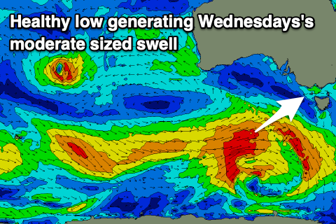
- Moderate sized SW swell Wed with gusty SE winds (possibly E/SE for a period east of Melbourne)
- Easing surf Thu with light E/SE tending fresh S/SE winds
- Reinforcing mid-period SW swell Fri with light S/SE winds, increasing through the day from the S'th
- Easing SW swell Sat with light SE tending S/SE winds
- New SW groundswell Sun AM with light NE tending S/SE winds
- Easing SW groundswell Mon and Tue with morning NE winds
Recap
A poor weekend of surf after great waves on the beaches through the end of last week. This morning conditions are a complete mess as a low deepens off the southern NSW coast
This week and weekend (Mar 8 – 13)
Looking at the coming week and we've got a poor few days of surf and winds ahead, with no real improvement in the wind direction into the end of the week but winds should ease and abate.
This will be due to a strong low forming off the southern NSW coast during tomorrow, stalling through most of the week as a strong high pushes in from the west. This will create a strengthening south-easterly pressure gradient across the state, bringing strong S/SE winds tomorrow, shifting SE into Wednesday, spoiling a good, new moderate sized SW swell.
 There's an outside chance of E/SE winds at periods through the morning east of Melbourne but in general conditions will be choppy and poor.
The source of the SW swell is a healthy polar low that's currently pushing east, south of Western Australia while generating a fetch of strong to near gale-force W/SW winds. It'll be consistent and moderate in size, coming in at 4ft+ on the Surf Coast and 6ft+ to the east.
Weaker, trailing fetches of strong W/NW winds will generate a reinforcing pulse of mid-period SW swell Friday with the Surf Coast due to hold around 3ft+ with 4-5ft+ sets on the Mornington Peninsula.
We'll see wind start to ease from Thursday as the low off the East Coast weakens and pushes east, but unfortunately they look to linger from the SE across the Surf Coast, tending light E/SE across the Mornington Peninsula and Phillip Island. While not great there should be some options for the keen but the swell will still be chunky. Friday looks a little less favourable with a light S/SE tending fresher S'ly breeze with the reinforcing swell.
Into the weekend winds look to linger out of the SE, light in the morning with easing levels of swell from Friday, back from 2-3ft on the Surf Coast and 4-5ft to the east.
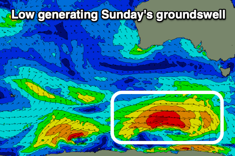 Later in the day Saturday a new SW groundswell should be seen, peaking through Sunday morning. This will be generated by a strong low firing up under the country on Thursday, with a tight fetch of gale to severe-gales forecast to be projected east. The swell should produce a good 3-4ft of swell for Sunday morning on the Surf Coast and 6ft sets to the east as winds finally start to improve, shifting NE through the morning ahead of sea breezes. With the size of the swell conditions will be tricky though.
Monday and Tuesday should be great for the beaches as the swell eases and offshore NE winds persist ahead of afternoon sea breezes.
Longer term, the outlook is slow for the rest of next week with no decent swells owing to the persistent progression of high pressure systems across our swell window. We may see some new swell later next weekend but check back through the week for more on this.
Comments
Was enjoying the new Woolamai cameras while they lasted, what’s happened there?
Power outage for "Critical Maintenance", due back around 4pm. https://www.outagetracker.com.au/
No worries, thanks Ben.
'Tis actually a frequent occurence on the Island. Not sure why though.
Not wired in by info are they?
Yes. Was wondering how long they would last. Awesome for the majority, not so for the minority if you know what I mean
Was chunky yesterday Craig with that easterly in it. 6' barrel peaks completely out of reach,
I didn't get to lay eyes on it yesterday. Any good? I was at a kid's party at a play center in Carrum Downs. More like a covid and gastro incubator to be honest. I was surfed out from last week anyway, glad I'm not a pro and have to surf all day every day.