Windy surf to come, improving slowly next week

Victorian Surf Forecast by Craig Brokensha (issued Friday 25th February)
Best Days: Tuesday morning exposed beaches, Wednesday exposed beaches, Thursday morning exposed beaches, Friday morning exposed beaches
Features of the Forecast (tl;dr)
- Moderate sized mix of SW and SE swells tomorrow, easing a touch Sun with strong E/SE tending SE winds
- Easing mix of swells Mon with fresh, dawn SE winds, tending moderate E/SE through the morning and strengthening into the PM
- Inconsistent SW swell building Tue with fresh E/NE tending strong E/SE winds, peaking Wed with strong E'ly winds, easing into the PM
- Slightly smaller, less consistent groundswell Thu with moderate E/NE tending SE winds, NE tending SE on Fri
Recap
Average surf the last two days with a drop in swell and moderate onshore winds, workable on the beaches to the east yesterday morning. Today winds are fresher and conditions are choppier with a small pulse of weak swell.
This weekend and next week (Feb 26 – Mar 4)
A strong high is sliding in from the west, squeezed by instability across the East Coast and this will see strengthening south-east winds develop through Bass Strait on the weekend, tending E/SE each morning east of Melbourne.
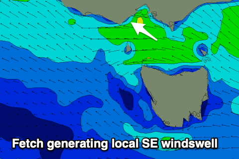 A poor mix of building SE windswell (on the Surf Coast) and new, mid-period SW swell (from weak frontal activity) is due, coming in at 3-4ft+ on the Mornington Peninsula and building to 3ft to the west.
The mid-period energy is due to start easing on Sunday as the SE windswell holds around 3ft on the sets across the Surf Coast with Monday likely to remain average across most locations.
It looks like winds will ease a touch and shift moderate E/SE through Monday morning but with average levels of easing SW swell from 2-3ft on the Mornington Peninsula and 2-3ft of SE windswell on the Surf Coast.
From Tuesday we should see winds slowly improve as the high continues its movement east, swinging winds around to the E/NE during the morning, fresh in strength along with some new, building inconsistent SW swell.
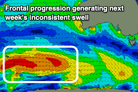
The source of the coming swell which looks to peak through Wednesday is a couple of back to back polar lows and drawn out fetches of strong to near gale-force W-W/NW winds moving in from the south-west of Western Australia.
At the back of the progression a stronger low will generate gale to severe-gale winds but west of the Heard Island region, in our far far swell window.
 What we can expect is fun levels of SW swell building Tuesday from 3ft+ across the Mornington Peninsula through the morning with the Surf Coast seeing 2ft+ of SE windswell, with the Mornington Peninsula reaching 3-5ft later in the day as winds strengthen from the E/SE.
Wednesday looks better with inconsistent 2-3ft waves on the Surf Coast and 4-5ft sets on the Mornington Peninsula with strong E'ly winds, easing in strength into the afternoon.
The swell is due to ease Thursday but the long-period, inconsistent groundswell energy should soften this trend with infrequent 2ft to occasionally 3ft sets due to persist on the Surf Coast all day, and 3-5ft waves to the east, easing Friday.
Winds should improve Thursday and ease while tending E/NE through the morning with great N/NE-NE winds on Friday morning as the swell eases.
Longer term we'll hit a slow patch ahead of some healthy frontal activity developing south-west of Western Australia later next week, bringing swell the week starting the 8th of March, but we'll provide updates on this next week. Have a great weekend!
Comments
Find a mirror Craig, take a long hard look..
Haha!
Nothing wrong here
Why are we paying for cams that don’t work?
To copy what I wrote yesterday in the "Why is that surfcam offline" forum thead:
Lorne and Fairhaven are offline, thanks to a faulty software patch.
Last year, NBN announced they were implement two new functions to VDSL2 lines, Save Our Showtime (SOS) and Robust Overhead Channel (ROC), designed to improve the stability of an internet connection.
We were told that modems needed to be compatible by early March, so yesterday afternoon we started rolling out firmware updates (provided by our hardware manufacturers).
All of the updates worked fine, except Lorne and Fairhaven, which were both using the same kind of modem (but different to the rest of the network). As such, these modems now appear to be bricked, and will require a site visit to rectify.
Our technician is flying in on Monday so we will have the surfcams back shortly afterwards.
Woolamai will also be upgraded on Wednesday.
And, we should have an ETA for 13th Beach soon (as the surf club redevelopment nears completion).
No rush Ben.
Please take your time and attend to more important matters.
Yeah its not like theres been anything worth looking at for the past 3 months+!!!