Poor surf over the coming days, much better next week

Victorian Surf Forecast by Craig Brokensha (issued Wednesday 23rd February)
Best Days: Today, selected beaches to the east for the keen Saturday and Sunday mornings, Monday morning east of Melbourne, Tuesday morning, Wednesday morning, Thursday morning, Friday morning
Features of the Forecast (tl;dr)
- Small mix of swells for the coming days with moderate S/SW tending S winds tomorrow, stronger S on Fri
- Building SE windswell Sat, holding Sun and easing slowly early next week. Strong E/SE tending SE winds Sat, fresh E/SE tending strong SE Sun
- Mid-period SW swell Sat on the exposed beaches, easing slowly Sun and further Mon
- Inconsistent SW swell building Tue, peaking Wed, with a reinforcing swell for Thu, easing Fri
- Moderate E/NE tending strong S/SE winds Mon, light NE tending S/SE on Tue and N/NW tending S on Wed
- Light NE tending SE winds on Thu and Fri
Recap
A good sized pulse of reinforcing S/SW swell yesterday but with bumpy conditions, workable across selected locations both east and west of Melbourne.
Today conditions are much smoother but there's lots of lump and wobble from yesterday's onshore winds with easing sets from 3ft on the Surf Coast and 4ft to the east. The surf should continue to improve (while easing) and iron out before sea breezes kick in by mid-afternoon.
This week and weekend (Feb 24 - 27)
Make the most of this morning as the coming days are looking poor for surfing. A surface trough will bring a moderate, onshore S/SW change before dawn tomorrow as the swell eases further in size.
It'll only be around 2ft on the Surf Coast and 2-3ft to the east while a poorly aligned mid-latitude front will bring some new, small W/SW swell for the afternoon. This may be a touch bigger on the sets but conditions will be average and not worth worrying about.
A strong high moving in behind the trough will squeeze against a series of inland troughs on Friday, bringing stronger S'ly winds and no new swell.
 As the weekend evolves we'll see the high sliding further east, tipping winds around to the south-east through Bass Strait while strengthening. Saturday should see strong E/SE tending SE winds and building levels of south-east windswell on the Surf Coast to 3ft through the day, holding Sunday with a touch less wind though still fresh from the E/SE in the morning, stronger SE into the afternoon.
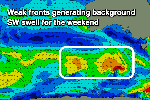
On the Mornington Peninsula there should be some small mid-period SW swell from a couple of weak fronts passing under the country today and tomorrow. 3-4ft+ sets are due Saturday, easing back a little Sunday from 3ft to occasionally 4ft.
As touched on in Monday's update, winds will slowly improve through next week as the inland instability shifts a little further west and south as the high pushes further east.
This will dip winds around to the E/NE on Monday morning with a peaky mix of easing swells to 2-3ft on the Surf Coast (sloppy) and easing 2-3ft sets to the east.
Tuesday should reveal a lighter NE offshore wind along with some inconsistent, building SW swell generated by a broad, slow moving polar frontal progression from the Heard Island region over the coming days and weekend.
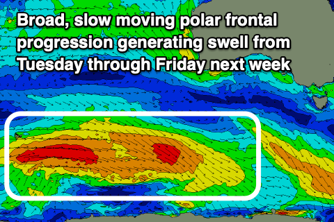 While weakening and not overly strong it should provide a prolonged, fun swell with building sets towards 3-5ft on the Mornington Peninsula into the afternoon Tuesday and 2ft+ on the Surf Coast, peaking Wednesday to 2-3ft and 4-5ft respectively. Winds on Wednesday look light out of the N/NW ahead of a trough and shift to the S'th through the afternoon, back offshore from the E/NE on Thursday.
The charts are showing some new, long-period energy into Thursday but this will be generated by the very distant, earlier stages of the polar frontal progression and isn't expected to provide any additional size and maintain infrequent 3-5ft sets on the Mornington Peninsula and 2ft to occasionally 3ft sets on the Surf Coast.
Friday looks fun with easing surf from 2ft and 3-4ft respectively with a light, morning NE offshore.
Longer term it looks like we'll see increasing activity through the Southern Ocean into the start of March, but more on this Friday.
Comments
Craig, quick question about the predictions on your Surf Forecast pages. You write "Tuesday should reveal a lighter NE offshore wind" but the charts on your forecast page shows near-gale force ESEs from early.
Generally speaking, how much stock can we put in those charts?
Hey Tim, our automated forecasts use GFS data, whereas I generally use EC for the local wind outlook and the hi-res ACCESS-R data for 36 hours out. So I'd be following the notes more so than the automated output.
Hi Craig, thanks for the summary! BoM marine wind forecast says it uses ACCESS (http://www.bom.gov.au/marine/wind.shtml?location=vic-mel&tz=AEDT) assume that's the same as ACCESS-R? Or -R denotes something different?
Then on some sites you can see "ICON" as well, but from some research that's only accurate in Europe so maybe less relevant to us here?
Cheers, Dan
Just found this - http://www.bom.gov.au/australia/charts/about/about_access.shtml - provides some info on what's what, looks like the link above is ACCESS-R considering it only goes to 72 hours. You might've already done one, but an article on the different wind models and what's best for what could be pretty interesting (without revealing too many of your secrets!)
Yeah good idea.
Hi Craig, just wondering when the woolamai cam will be fixed?
Very soon, just trying to arrange a site visit (the equipment was sent down a while ago).
13th ?
Waiting for a NE....fair enough
Make sure there is swell and it is offshore, not an easy task in Victoria for the last 3 months.